First Look: Four Concept Plans For OLF-8 Development In Beulah
October 18, 2020
The public is getting a first look at four initial concept design plans for OLF-8 in Beulah.
The OLF8 Master Plan project is an Escambia County-driven initiative to turn the empty helicopter field by Navy Federal Credit Union Campus into a thriving asset for the community. The project team, led by DPZ CoDesign, was selected by the Escambia County Commissioners to create a plan to maximize the opportunities for jobs and community uses on this 500 plus acre site along Nine Mile Road.
After hundreds of survey responses, comments, stakeholder meetings, and seven public virtual meetings, the four concepts were unveiled last week.
Each plan has a different approach to using the 500+ acres at OLF-8, but all the plans incorporate best practices for urban design, use of space, green infrastructure, and traffic management.
The plans are dubbed The Commerce Park Plan, The Market Plan, The Greenway Plan and The Village Plan.
There are certain common ideas weaved in all the plans. The differences between the plans are primarily in the amount of land devoted to each use (residential, commerce, retail, recreation, civic, etc), the intensity and diversity of development, and the character and design of the site.
Each of the four plans are detailed below:
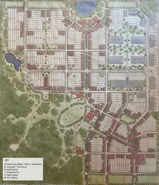
The Commerce Plan
This is the plan that develops the site exclusively for a commerce park, life-style center (for the downtown) and recreational amenities. There are no residential housing in this plan.
- Organization – A lifestyle center of retail shops along pedestrian-oriented streets is located near 9-Mile Rd, and commerce park uses are located north nearer to Frank Reeder, where the site is relatively flat.
- Marketability – This plan far exceeds market capacity for commerce park uses; but one can see where the plan may be reduced or provide for development opportunity into the future for other uses.
- Walkability – Creates walkable streets where possible, particularly in the southern lifestyle center and the office center spine. Otherwise, the commerce format is not easily compatible with walkability. A diversity of commerce and industrial type buildings are suggested here.
- Transportation – The street grid is well organized, however due to the lack of housing each job and business will create a significant amount of car traffic at peak hours along 9 mile and Frank Reeder.
- Environment – The plan preserves open space along the edges, but the format requires substantial surface parking which results in excess water run-off.
- Edges – Edges to the north, west, and south remain open with trails. To the east the edge includes a few future street connections near 9-Mile Rd but does not buffer further north where substantial tree stands border the site’s edge.
- Innovation – Flexibility in the block structure is the key innovation, where the plan could adjust to accommodate other uses.
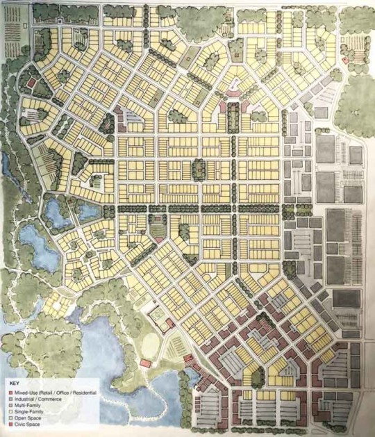
The Market Plan
This is the plan that develops the site according to the results of the marketability study. Absent community input, this is what we would call the highest and best use plan which would yield the highest return on investment.
- Organization – A mixed-use neighborhood center, with a retail loop, is anchored to the south end of the OLF8 site with access from 9-mile road. The rest of the plan is developed as residential neighborhoods, each with a possible distinct character, centered on a central green. A 70-acre site, along the west side is reserved for a commerce park.
- Marketability – It meets the mix of residential, retail, office, and light industrial uses identified by the Weitzman report.
- Walkability – The neighborhoods are laid out along narrow streets. In terms of transportation – a clear and connected grid of streets and trails are organized around the building blocks of each neighborhood. Wider streets separate one neighborhood from another.
- Environment – Preserves the current open space and treed area and expands on this by bringing greens deep into site through green fingers which turn into wide boulevards. Smaller scaled pocket parks are embedded in the various neighborhoods, ensuring everybody has close access to some form of open space within a 5-min walk.
- Edges – This plan preserves a buffer of 200 to 400 feet in width along Frank Reeder Road to reflect the current character on the north side of Frank Reeder Rd.
- Innovation – There are multiple scales of small farms ranging from 1 acre to 10 acres, to protect and celebrate the rural history of the area. A necklace of public amenities are anchored to the natural area on the west side of the site, which include, a micro-brewery located on a small lake, a boutique hotel across from the brewery, a children’s museum (similar to the ‘Mess Hall’), an elementary school, a community garden, with a functioning barn to harvest produce, a market building to sell the freshly grown produce, and finally a Children’s day care center, connected to Navy Federal.
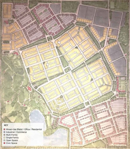
The Greenway Plan
This is one of two hybrid plans with a more limited mix of uses than the marketability plan suggested could be accommodated on site.
- Organization – This plan is defined by a grid of greenways. The town center is located along 9-mile Rd with a mix of offices, shops, restaurants and some multi-family buildings. An eastern industrial commerce district is suggested with entrances of 9-mile Rd. It wraps around the north and NW corner along Frank Reeder which anticipates the 1-10 interchange at Beulah Rd. A central low-density residential neighborhood is proposed for the center, with 4 quadrants defined by large attached greens and a street of live-work units. A north-south main street spine and broad greenway ring road connect all 4.
- Marketability – The plan provides for a healthy mix of all market uses that are likely to be desired in this region and a flexible framework to make market adjustments as the project is built incrementally.
- Walkability – Each neighborhood is designed to have a quarter mile radius (5 min. walk) from center to edge. Amenities and Civic facilities are distributed throughout site, with plentiful array of green space. The broad greenway features shared walking trail for walkers, joggers and equestrian riders down the center.
- Transportation – Neighborhood structure provides centrally-located pick-up locations within 5 minute walks of each address for both regional bus transit or local shuttles.
- Environment – The Greenway system connects directly with the southwestern park. New stormwater ponds create a focal point for the retail and restaurant at the town center edges, and help manage the stormwater drainage needs of the site. The trail system, for both people and horses, continues into the large park in the southwest that incorporates the wetlands and existing tree stands with passive and active recreation, as well as civic uses and community farming.
- Edges – Bands of green space frame the entire site and are integrated into the Greenway system of this community. Roadways into the privately owned western properties are avoided and views screened, but future connections are not precluded. A connection to Navy Federal is anticipated on the east side.
- Innovation – A modular block structure offer incremental phasing and future flexibility. It is envisioned that this central neighborhood could remain open space initially, and then be phased incrementally as the demand arises.
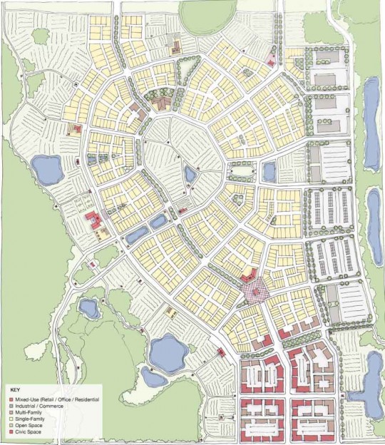
The Village Plan
This is one of two hybrid plans, and is focused around Beulah’s agrarian and rural roots. It is the least developed of the 4 plans
- Organization – A commerce park is embedded along the eastern end of the site. A village center with shops, housing and office uses along pedestrian-oriented streets is located on the south end of the plan, along 9-mile Road, while a centralized agricultural or common green space serves as a key community feature, surrounded by quiet residential neighborhoods and amenities such as a winery and restaurant. The village boundaries transition into agriculture and then nature.
- Marketability – While potentially not at full market capacity for commerce or housing, this plan provides for a unique and active agrarian community experience. It is the plan with the least amount of residential proposed.
- Walkability – Mid-block shared streets, multi-use paths, destinations, scenic agrarian vistas and unique pedestrian experiences allow for useful and interesting daily walks in this plan.
- In terms of transportation – This plan aims at reducing the street network load and provides a diverse variety of options including an interconnected trail system accessible for equestrian, biking, walking and other active recreation and transportation uses.
- Environment – The wetlands and wooded areas remain intact in this plan with substantial land preserved for open space, agriculture and minimal impact recreational uses.
- Natural elements are also integrated within the village and open green spaces serve as stormwater retention ponds when needed.
- Edges – Except for the village center edge along 9 Mile road to the south, the site retains natural edges throughout, composed of wooded areas, agriculture, greenways and paths.
- Innovation – This plan takes on a traditional village concept where the village boundary is defined by farmstead and agrarian parcels while providing a flexible block structure within for a variety of uses.
Comments
27 Responses to “First Look: Four Concept Plans For OLF-8 Development In Beulah”


I hear a lot of complains about our commission yet no one takes any real action. Want to save your area, then get together with your like-minded neighbors and petition to incorporate the area. Then their will be local control with a fine tax base. Or keep up with the ways of old and let one commissioner influence just two of his fellow commissioners to do as he pleases. The lack of representation is due to the apathy of the people.
Future generations look at this like, what will we have?? What will we have ?? You know they have a point maybe we should leave something for the future generations! At
Idle the bulldozers eeh!
Cheap strip mall rather!
Just another character strip mall
This land needs to stay as is, we cannot trash every single acre in north west Florida. Only folks who want it is contractors so they can make money on it then once it’s complete what do you have? Another McDonalds?? Let’s strike this down
Beula residents should have sold out and moved 10 yeas ago.
Thank God that they did not place that credit union on 29 North.
Why isn’t one of the options to do nothing? Maybe the highest and best use is what the community wants not what makes a select few more money and power. How about redevelop some of Pensacola and leave Beulah alone. How long before the Equestrian Center is “developed”? I have seen this greed play out in several cities and it ends badly for the residents. Take a look at Baton Rouge for example.
Question: All of the new communities build out here are behind locked gates.
I suspect all of the amenities and pleasantness of this “community”
could also end up behind the gate as well. Could a planner be able to
answer this question currently?
Sell the property. Escambia County’s government should not be in the business of buying and developing land. These are the ways of socialistic governments. If I could tax the people of the county with the law backing me, I might be able to buy some nice pieces of property and develop them too. Sell the property, cut taxes and regulations and let us enjoy more freedom.
The word “planning” and Escambia county should not be used in the same sentence.
No I don’t believe the community input will do much good. It is nothing more than a dog and pony show to make you think you have some input but the county and the developers will do what they want and on the time schedule they choose. Don’t forget, commissioners bought this property without discussing it with the community to begin with and then sold some of it to Navy Federal, again without community input. The results…utter chaos on 9 Mile Road while construction goes on with no end in sight.
This master plan is better then the usual suspects of a big parking lot with a Walmart and fast food joints. The development is going to happen regardless of anything, so it’s in the best interest of the community to engage in this process to get the best possible outcome. Also, the project stands outside of 9 mile road completion, and in fact, has not even broken ground yet on the development — thus the community planning effort pre-development.
Your voice matters in this process! It’s rare that a community gets to influence big business interest to keep our soul. All of us that live here are in a unique position to have a say in what will be done. Join in and look at the plans and have a say in it. We may not be able to stop progress, but we can have a say in how we want it to be!
They can plan on all that construction yet we can”t get one additional lane northbound on Pine Forest Road from Detroit Blvd to 9 mile road?
So the county commissioners sold their souls to the builders. Leave the property as it is. Put a small parking lot to one side and make a running track wide enough for runners and walkers. Finish 9 Mile Road!!
Why don’t we leave it be for a while. Haven’t we had enough construction going on in the last few years. Let’s at least wait until they finish 9 mile road and highway 29 for Gods sake.
I’m pro progress. Yet I believe our infrastructure is not ready to handle this project. Let’s finish the construction on Pine Forest rd, Nine Mile Rd as well as 29/Pensacola blvd that started approximately 3 years ago. Hurricane Sally shows us that our holding ponds drainage still behind other areas in the state and country and need major improvement.
Develop yes! Finishing old projects first better!
I really thought the park, public space idea would be the choice from what I read in comments when asked about usage input. Should have known better. Public land to be stolen and sold, increasing problems and crime. Greedy, greedy, greedy.
All of these options represent growth for the community. Has an athletic park been considered for the children of Beulah as a part of the OLF-8 development? Currently the children heavily use the Beulah park on Mobile Hwy, however they have to be transported a minimum of 25-30 minutes in the evenings to play recreational sports. There are many children and families in Beulah who would benefit from these after school activities. The creation of this facility would promote unity in the community and encourage more young families to move to the area.
I moved out here over 25 years ago to get away from what you are projecting to do with the air field. I liked the quiet semi-rural community where I could see stars at night and hear small night sounds from frogs and other small animals Now all I hear is construction equipment by day and sometimes at night and I don’t see the stars. And I am not in a position to sell and move so I am stuck in a city situation of one kind or another.
Did I overlook something or is there not a park for the kids to have a place to play. There isn’t anything in this plan that I see that will be good for our kids. Why don’t we set aside at least two acres for a park and future development for our kids. Our kids are our future lets do something to promote that.
No more apartments or housing. My poor Beulah has been ransacked and taken over by big business money which includes our crooked commissioners. I miss the quiet serenity of our country community and any further development is not needed. Please just leave it alone for a few years.
Our family has adjusted to the traffic and growth in the Beulah community. Traffic continues to be a problem. We hope the developers and Escambia County will correct the problem before any more growth in the Beulah community.
I like the Village Plan due it has room for further building in the future. Second preference is the Greenway Plan. Need to keep some room for a little bit of growth.
If you think traffic is bad now on 9 mile road,
just wait till this goes in. Glad I don’t live anywhere
near there.
Is there a shortage of industrial/commerce space in Escambia county of which I am unaware? I’ve been here twenty years, and I don’t believe Elysan Field has ever reached full capacity in that time. In addition, isn’t there a big industrial park going in along the Escambia river north of the UWF campus? Why is that even being considered for the landing field 8 property?
Let’s hurry and build a high density development in an area that already has roads that are beyond their capability. You have to wonder; Who benefits from this kind of project, the citizens of the county, or the Commissioners and their crony buddies?