Escambia County Flood Maps Are Changing, And They Could Impact Construction And Insurance Costs
April 15, 2021
New flood hazard maps for Escambia County are ready for public review. The preliminary maps are the result of a multi-year project to develop accurate and detailed digital flood maps for the Florida Panhandle Region, based on data from the latest mapping and modeling technologies.
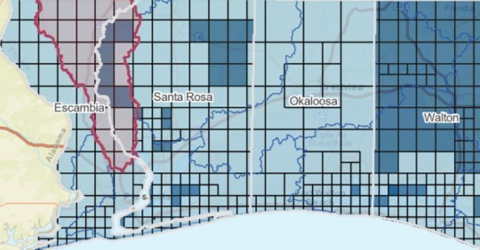
TO VIEW THE INTERACTIVE ESCAMBIA COUNTY MAP WITH MAP LEGENDS, CLICK OR TAP HERE.
The Northwest Florida Water Management District is releasing the updated maps in cooperation with the Federal Emergency Management Agency and communities throughout Escambia County. The new maps reflect current flooding risks, replacing maps that are based on outdated studies, some of which are more than 30 years old. Revisions to these mapping products may affect residents and business owners in Escambia County.
Residents and businesses will want to be aware of how the maps are changing, how the changes may affect new construction and rebuilding decisions, as well as requirements for flood insurance. Property owners are encouraged to visit Northwest Florida’s Virtual Flood Risk Open House to better understand the project and changes linked here.
Northwest Florida’s Virtual Flood Risk Open House provides information relevant to the proposed changes in flood risks in your community, as well as an opportunity to connect with floodplain management experts from your local jurisdiction, NWFWMD and FEMA.
In-person virtual meetings are available by appointment only and can be reserved on the website, via the “Connect with Us” page of the Virtual Flood Risk Open House linked here. Appointments will be held between May 18 and June 3, 2021. Appointments can be reserved between May 3 and May 14, 2021.
A 90-day public comment period will soon be open to address any submitted appeals and/or comments. Another notice will be sent when the public comment period opens. After all appeals and comments are addressed, the maps are expected to become effective in early to mid-2022. At that time, the new insurance requirements will take effect.
To learn more about the preliminary maps, see what areas will change, learn what the insurance options are and find the schedule for related community meetings, visit the link here.
For general information about the upcoming map changes, you can contact:
Escambia County
- Harry Gibson, Building Inspections Department, Floodplain Administrator 850-595-3550
- Jennifer Hampton, Building Inspections Department, Floodplain Manager 850-595-3550
Town of Century
- Debbie Nickles, Town Planner, Town of Century 850-994-0081
City of Pensacola
- Jonathan Bilby, Floodplain Administrator, City of Pensacola 850-436-5600
Santa Rosa Island Authority
- Juan C. Lemos, Flood plain Manager, Santa Rosa Island Authority 850- 932-2257
Comments
12 Responses to “Escambia County Flood Maps Are Changing, And They Could Impact Construction And Insurance Costs”


Is the requirement for 3 feet above BFE still apply?
trying to figure out were my property is in this map fixing to build a new home , the appraiser said 2 different sites has us in A, and AX WE HAVE NEVER FLOODED
shilston branch rd
FEMA increased rates in January, then again in April for some policyholders. With the upcoming Risk Rating 2.0 program in October this will effect rates again. However, FEMA is not the only option for flood insurance. The private flood market has grown tremendously and these carriers can offer more coverage options and competitive premiums. Check out http://www.myfloodinsurance.com to get INSTANT, real-time private flood insurance quotes!
Insurance rates go up, Flood insurance goes up. Food prices go up. Prescription prices go up. Fire dues go up. Taxes go up. Utilities goes up. Does anything go down? I also know my Social Security does not go up because Medicaid goes up and takes away my COLA. How do retired people go forward to live into the future…. Bureaucrats answer to all problems is to raise prices to everything.
So the map includes escambia river. But doesn’t include any of eleven mile creek. Epic failure. I live on the south end of eleven mile creek off mobile hwy in a place built in the 1800s. Never flooded until 2014 and Sally. Water had been in yard a few times but no where near the house until then. 6 ft in yard 2014. 3 ft in Sally. All that development the county allowed north of the interstate has caused a bad problem. And new subdivisions on klondike rd and nine mile rd it’s only getting worse. Incompetent leaders.
mark my word,
the flood plan will only get
larger as Escambia comm refuse
to anything about the basic problem.
Escambia river is filling up mud and silt.
and until they clean out the river it only
going to worce.
What does the white X mean? You can see the map and click on your property but the legend doesn’t provide explanations
>>Where is the key or legend in order to understand this map??
Follow the links in the article. It’s very convoluted to find the maps once you click the NWFWMD links. (you know what government websites can before).
We’ve also gone back and made the graphic on this page clickable to the actual map, and added a clearer link at the top of the story to skip the presentation and see the Escambia County map.
Where is the key or legend in order to understand this map??
Escambia county has not got any smaller nor has the sea. a l
leave it to the county to make a map and not tell you anything. there is nothing to say what colors on the map represents. when I click on my county there is no other popups to tell me anything. I Know already I live in. a flood zone. did they really spend tax payer money to do all this and not tell you anything???
Is it me or did they just put almost all of Escambia County in a flood zone? Them insurance companies are probably licking their chops with this rate increase to follow.