Tropical Double Threat In The Gulf: Tropical Storm Laura Forms; Second Tropical Storm To Form
August 21, 2020
THIS STORY IS OUTDATED. SEE NORTHESCAMBIA.COM FOR THE LATEST WEATHER INFORMATION.
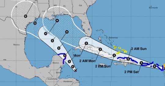
All eyes are on a tropical double threat as there will likely be two tropical storms, or possibly hurricanes, in the Gulf of Mexico by early next week.
Tropical Storm Laura in the tropical Atlantic headed west-northwest and continues to not be well organized this morning. The current track brings this system into the eastern Gulf as a hurricane early next week. There remains too much uncertainty at this point to pin down potential local impacts, outside of an increasing ripcurrent risk.
Tropical Depression #14 is currently moving northwest near the coast of Honduras and is expected to enter the southern Gulf of Mexico later this weekend. Again, it’s too early to determine impacts here locally (if any) at this point.
There is a lot of uncertainty in the track and intensity of these systems. It’s tough to pinpoint specifics at this point. Rain chances and winds will be driven significantly by the track of these systems.
The latest specific information is the graphics on this page.
Comments
3 Responses to “Tropical Double Threat In The Gulf: Tropical Storm Laura Forms; Second Tropical Storm To Form”


If the storms are close enough in strength for some Fujiwhara effects the wind shear from both storms will most likely weaken the other or inhibit the storms being able to get further organized.
It will be interesting to see how these storms affect tidal surge depending on if the storms interact or if one storm follows the other. I’m sure the pumps in NOLA will be working overtime to keep up.
2020… Both barrels red hot so far. Winter we either gonna have 5 feet of snow or 10… But things show are a bit blurry in this year of 2020..
I don’t know…First time I have ever seen 2 storms hit the Gulf Coast within 24 hours of each other and in the year of a pandemic.
Seems like a sign your life better be in order.