Escambia County Offers Free Sand For Storm Preparation
July 11, 2019
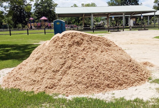
Escambia County is offering sand for residents living in flood-prone areas. The sand is available on a first come, first served basis.
Residents must bring their own sandbags and shovels to one of the following locations (map):
- Baars Field Athletic Park – 13001 Sorrento Road, Pensacola
- Brent Athletic Park – 4711 N. W St., Pensacola
- Don Sutton Park – 2320 Crabtree Church Road, Molino
- Equestrian Center – 7750 Mobile Highway, Pensacola
- Escambia County Road Department – 601 Highway 297-A, Pensacola
- Ferry Pass Middle School – 8355 Yancey Lane, Pensacola, sand will be on the northwest corner of school property on Parazine Street
- John R. Jones Jr. Athletic Park – 555 E. Nine Mile Road, Pensacola
- Travis M. Nelson Park - 4541 County Road 4, Bratt
Sand bags can be purchased at most local hardware or home improvement stores, typically for a low cost.
Pictured: Sand at Travis M. Nelson Park in Bratt Thursday afternoon. NorthEscambia.com photos, click to enlarge.
Cantonment Man Allegedly Threatened To Shoot His Wife And Daughter
July 11, 2019
A Cantonment man allegedly threatened to shoot his wife and daughter during a disturbance.
 Arthur Linwood Emerson, 62, was charged with two felony counts of aggravated assault with a deadly weapon.
The Escambia County Sheriff’s Office says they responded to a disturbance on Filley Road after receiving reports that Emerson had a gun and made the statement that he was going to shoot everyone.
When deputies arrived at the residence, they were told that Emerson had waved the gun towards his daughter and his wife. Deputies could hear arguing coming from the garage as they approached and found Emerson sitting in a chair inside. Emerson was taken into custody, and a Remington .380 was located in right front pocket.
His wife told deputies that he had been drinking and an argument ensued over the daughter not keeping a job, according to an arrest report, before he waved the gun and threatened to shoot.
Emerson told deputies that he did have the firearm in his possession, but he never pulled it out, the report states. He said he would never hurt his wife or daughter.
Emerson was released from the Escambia County Jail on a $2,000 bond.
Tropical Storm Barry Update
July 11, 2019

The disturbance in the Gulf of Mexico strengthened into Tropical Storm Barry on Thursday, moving toward a landfall in Louisiana this weekend. Further strengthening during the next 72 hours is forecast.
The latest information on Barry is in the graphics on this page.
The system is also expected to produce total additional rain accumulations of 6 to 12 inches near and inland of the central Gulf Coast through early next week, with isolated maximum rainfall amounts of 18 inches. Rainfall amounts exceeding 6 to 9 inches occurred across portions of the New Orleans metropolitan area Wednesday, resulting in flooding.
LOCAL IMPACTS
A flash flood watch is in effect through Sunday for the North Escambia area. In Escambia County, we are expecting 3-5 inches. Depending on how rain bands set up during this event, we could see even higher amounts in rainbands that repeatedly move over the same areas. The bulk of the rain will begin overnight Thursday into early Friday and extend through the weekend. We can expect our usual afternoon showers and storms.
Coastal flooding is possible beginning Friday and continuing into Sunday, especially during high tide in the mid-morning hours. A coastal flood watch is in effect Friday through Sunday afternoon.
There is high risk of rip currents with high surf of 5-8 feet.
For the local weather forecast, click here.
![[Image of probabilities of 34-kt winds]](https://www.nhc.noaa.gov/storm_graphics/AT02/refresh/AL022019_wind_probs_34_F120+png/024638.png)

![[Image of WPC QPF U.S. rainfall potential]](https://www.nhc.noaa.gov/storm_graphics/AT02/refresh/AL0219WPCQPF+gif/024638WPCQPF_sm.gif)
![[Image of WPC Flash Flooding/Excessive Rainfall Outlook]](https://www.nhc.noaa.gov/storm_graphics/AT02/refresh/AL0219WPCERO+gif/024638WPCERO_sm.gif)
Local Forecast: Flash Flood Watch
July 11, 2019
A flash flood watch is in effect through Sunday.
For more on the tropical system in the Gulf, including the storm track and wind forecast, click here.
Here is your official North Escambia area forecast:
Tonight: A 30 percent chance of showers and thunderstorms. Mostly cloudy, with a low around 76. East wind around 10 mph.
Friday: Showers and thunderstorms. High near 85. Southeast wind 10 to 15 mph, with gusts as high as 25 mph. Chance of precipitation is 80%. New rainfall amounts between three quarters and one inch possible.
Friday Night: Showers and thunderstorms likely. Cloudy, with a low around 75. Southeast wind around 15 mph, with gusts as high as 20 mph. Chance of precipitation is 60%. New rainfall amounts between a quarter and half of an inch possible.
Saturday: Showers and thunderstorms. High near 84. South wind 10 to 15 mph, with gusts as high as 25 mph. Chance of precipitation is 80%.
Saturday Night: Showers and thunderstorms likely. Cloudy, with a low around 73. Southeast wind around 10 mph. Chance of precipitation is 60%.
Sunday: Showers and thunderstorms likely. Cloudy, with a high near 84. South wind around 10 mph. Chance of precipitation is 70%.
Sunday Night: A 50 percent chance of showers and thunderstorms. Cloudy, with a low around 72. South wind 5 to 10 mph.
Monday: A 40 percent chance of showers and thunderstorms. Mostly cloudy, with a high near 88. South wind 5 to 15 mph.
Monday Night: A 30 percent chance of showers and thunderstorms. Mostly cloudy, with a low around 74. South wind 5 to 10 mph becoming light after midnight.
Tuesday: A 40 percent chance of showers and thunderstorms. Partly sunny, with a high near 90.
Tuesday Night: A 20 percent chance of showers and thunderstorms. Partly cloudy, with a low around 74.
Wednesday: A 40 percent chance of showers and thunderstorms. Partly sunny, with a high near 92.
Wednesday Night: Partly cloudy, with a low around 75.
Thursday: A 40 percent chance of showers and thunderstorms. Partly sunny, with a high near 93.
Deputy Adopts Kitten He Rescued From Storm Drain
July 11, 2019
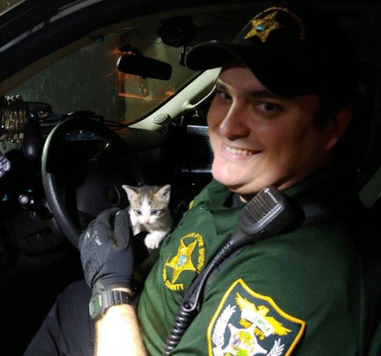
An Escambia County Sheriff’s deputy has a new furbaby that he rescued from a storm drain.
Deputy C. Bowling was working patrol last week and stopped at a Tom Thumb near Pace and Navy Boulevards. As he returned to his vehicle, he heard crying in dark and took off to find the source. After some searching, his flashlight caught some movement in the storm drain.
His flashlight revealed two tiny eyes staring back at him. He tried to use some tuna to lure the kitten out but the kitten was so young he wasn’t interested. Deputy Bowling was finally able to get close enough to the kitten to grab it. The poor thing was dirty and flea-covered and no mother could be located.
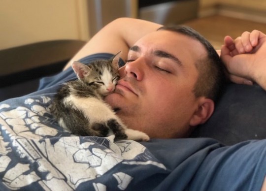
When Deputy Bowling took the kitten to the vet to get him medical attention, the vet said had he not rescued the kitten when he did that the kitten would have not made it. Deputy Bowling and his wife adopted the little kitten and named him Rambo.
Rambo is doing well, now clean and flea-free. Rambo, as pictured below, is definitely enjoying his new home and snuggle time with his new family.
Escambia County To Provide Century Redevelopment Area Executive Director
July 11, 2019
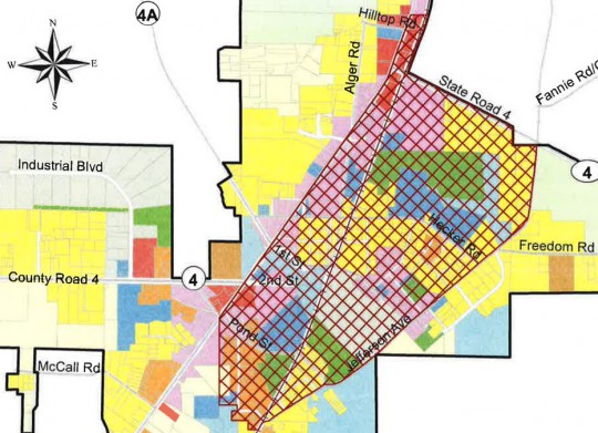
Escambia County will provide an executive director for the the Century Community Redevelopment Agency (CRA) through an interlocal agreement that is in the works.
The Century town council, acting as the CRA board, will meet Monday, July 15 at 6 p.m. at town hall, and the county will consider the interlocal agreement at their July 18 meeting.
In October 2018, the council approved a Tax Increment Financing plan for their redevelopment area, allowed the CRA to receive property tax revenues each year in excess of an established base rate. The appraised value of the property within the designated district was “frozen”this year, with that amount of tax revenue generated still designated for the town’s general fund, the county and other taxing authorities.
The redevelopment area will receive 95 percent of the property tax generated in excess of the frozen base value as property values rise. It is estimated that will amount to about $10,000 the first year for the beginning in 2020.
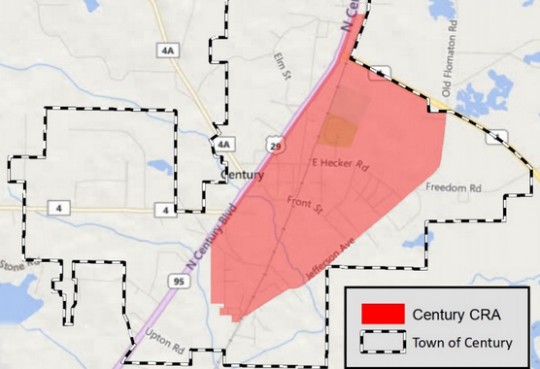
The CRA funds will be used to improve conditions in the 510 acres, bounded by Jefferson Avenue to the south, Jefferson Avenue to the east, East High 4 to the north and the center line of North Century Boulevard to the west. It also extends north on the east side of North Century Boulevard to include commercial properties up to, and including, the former Burger King.
The CRA received no funding to date because the base year for tax increment financing was established in 2018. The CRA will see its first redevelopment trust fund money next fiscal year.
Tax Increment Financing is a unique tool available to cities and counties for redevelopment activities. It is used to leverage public funds to promote private sector activities in the targeted redevelopment area. Property owners in the CRA will pay the same tax rate as those in the remainder of the town.
TIF revenue can be used on a “pay as you go” basis, where the annual stream of revenue is used to fund small projects, or used to pay debt service costs over the life of a project lasting 10 or more years. Historically in Florida, TIF has been effective at generating large amounts of funding for capital investments for roadway improvements, flood control programs, water and sewer and drainage infrastructure improvements, parking lots and garages, neighborhood parks, sidewalks, street and sidewalk tree plantings, signs and building construction.
After a February 2016 tornado damaged or destroyed 40 homes and businesses, the town looked to address the long-term effects on the community of a downturn in economic development. That led to the redevelopment area.
The CRA plan sets a roadmap for future development and spending to eliminate existing conditions of blight and to encourage continued private investment. The plan also provides a framework for coordinating and facilitating public and private redevelopment within the area.
Review the Century CRA plan by clicking here.
NorthEscambia.com images, click to enlarge.
Free Soccer Clinic For Kids Ages 5-12 Next Week
July 11, 2019
Pensacola Sports will hold its 8th Annual Kickstart Soccer Clinic July 16-18. It is a free, fun and safe introduction to the sport of soccer for kids ages 5-12.
All participants will receive free soccer instruction from local high school and club coaches, as well as a ball, shin guards, and other giveaways from event sponsors.
Kids ages 5-8 will check-in at 8:30 a.m. with instruction from 8:45-10:15 a.m., while kids ages 9-12 will be from 10:15 a.m.-12:00 p.m. This schedule will continue all three days, weather permitting.
Participants must wear closed-toe shoes (cleats are not mandatory) and are encouraged to bring a water bottle, hat, and sunscreen.
In addition to the instruction, the Escambia County Sheriff’s Office will be providing several demonstrations for the participants.
Online registration is available through the start of camp. To register, or for more information, click here. Onsite registration is also available each morning before the clinic begins. The clinic will be held at the Brent Football Field located at 4711 N. “W” St.
Search Underway For Escaped Alabama Prison Inmate
July 11, 2019
A prison inmate sentenced in Escambia County, AL, escaped from a work release center Wednesday night.
Travis Wyatt Dawson, 41, escaped from Loxley Work Release at about 9 p.m. He was last seen wearing a black t-shirt and black pants.
Dawson was sentenced to 20 years in 2013 on a possession of a controlled substance conviction in Escambia County, AL.
Anyone with information on his whereabouts is asked to call the Alabama Department of Corrections at (800) 831-8825 or 911.
The Blue Angels Air Show Schedule Remains Unchanged
July 10, 2019
The Blue Angels air shows are still on at Pensacola Beach Thursday through Sunday, despite rumors and erroneous information being shared on social media.
With a tropical weather system expected in the Gulf Of Mexico, the Blues say they will wait until the last minute to make any cancellation announcements.
“As of right now every show scheduled is still on track. We won’t cancel any part of the scheduled itinerary until the last possible moment, that way we don’t cancel Saturday’s flight and it ends up being a blue-skied sunny day,” MC2(SW) Christopher Gordon, Blue Angels Public Affairs, told NorthEscambia.com. ”So as of right now every flight is still a go. We will be sure to update everyone as soon as we get the information.”
In order to fly, the Blue Angels need the wind to be under 25 knots (28.76 mph) and a visibility of at least three nautical miles (3.45 statute miles). However, if air show organizers (the Santa Rosa Island Authority), cancel the show, the Blues can’t fly.
Here is the schedule, as it stands now, for the Blue Angels:
- Thursday: Practice over Pensacola Beach at 2 pm.
- Friday: Practice over Pensacola Beach 2 p.m.
- Saturday: Show time at 2 p.m.
- Sunday: Weather make-up day only. Flight time TBD.
NorthEscambia.com photo.
What Will This Gulf Storm Mean For Escambia County? Here Are The Details
July 10, 2019

As we continue to watch the development of what will become Tropical Storm and then likely Hurricane Barry over the Gulf, here are the complete details on the local impacts in North Escambia and surrounding areas, directly from our partners at the National Weather Service in Mobile:
LOCAL IMPACTS
- A flash flood watch is in effect through Sunday afternoon.
- Regardless of the eventual track and intensity of the system, our confidence is increasing in heavy rainfall later this week (especially along the coast).
- Rain will increase in coverage across the region through the week and weekend. The potential for heavy rain is trending higher with rainfall amounts of 5-7 inches possible mainly for southeast Mississippi and southwest Alabama (further north and east of there, expect a general 3-5″). Depending on how rain bands set up during this event, we could see even higher amounts in isolated areas. The bulk of the rain will begin overnight Thursday into early Friday and extend through the weekend. Expect our usual afternoon showers/storms beforehand.
- Potential for coastal flooding will depend on the movement and strengthening trend of the system. At this point, it is prudent to consider that minor coastal flooding (1-3 feet) is possible beginning Friday and continuing into Sunday. Depending on the track of the system, more significant coastal flooding may occur especially over coastal Alabama.
- High Rip Current Risk and increased surf is expected starting Thursday through at least the weekend for coastal Alabama and northwest Florida beaches.
THE SCIENCE
- A broad low pressure system located over the northeast Gulf of Mexico has become a little better defined this morning. The system is currently experiencing some northerly vertical wind shear, but the shear is expected to gradually subside over the next day. This system still has a HIGH CHANCE of becoming a tropical depression or storm by Thursday.
- Some erratic motion will be possible over the next 24 hours or until a well-defined center develops. That said, the general motion is expected to be toward the west-southwest or southwest. By Friday, it is forecast to turn toward the west-northwest and then turn northwestward by Saturday into a break in a deep-layer ridge (currently extending from the southeastern US westward across the southern Plains and into the Desert Southwest). The timing of the ridge breakdown owing to a shortwave trough moving southeast out of the northern Plains will be critical since a later/earlier turn by the cyclone would shift the track west/east of the current forecast.
- Only slow strengthening is expected for the next 24-36 hours due to the lack of a well-defined center and inner-core wind field, along with some modest northerly wind shear. By 48 hours and beyond, the combination of atmospheric and oceanic conditions become ideal for intensification.
WHAT IS A POTENTIAL TROPICAL CYCLONE?
- Potential Tropical Cyclone was a “new product” back in 2017. It allows the weather service to have the option to issue advisories/watches/warnings for disturbances that are not yet deemed a tropical depression or tropical storm (not fully formed), but which pose the threat of bringing tropical storm or hurricane conditions to land areas within 48 hours. These systems are known as Potential Tropical Cyclones in advisory products and are numbered from the same list as depressions. Because of the threat to the Gulf Coast, advisories have been initiated on Potential Tropical Cyclone #2 (further west of our area, toward Louisiana).
- Under previous longstanding NWS policy, it was not permitted to issue a hurricane or tropical storm watch/warning until after formation of the tropical system. Advances in forecasting over the past decade now allow the confident prediction of tropical impacts while these systems are still in the developmental stage. For these land-threatening “potential tropical cyclones”, the National Hurricane Center can issue the full suite of text, graphical, and watch/warning products that previously has only been issued for ongoing tropical systems.


