

Scott Closes State Offices In 35 Counties
October 9, 2018
Gov. Rick Scott said Monday state offices will be closed in 35 counties where he has declared a state of emergency because of Hurricane Michael. Scott said in a tweet that the offices will be closed from Tuesday through Thursday. The 35 counties are Escambia, Santa Rosa, Okaloosa, Walton, Holmes, Washington, Bay, Jackson, Calhoun, Gulf, Gadsden, Liberty, Franklin, Leon, Wakulla, Jefferson, Madison, Taylor, Columbia, Hamilton, Suwanee, Lafayette, Dixie, Gilchrist, Levy, Citrus, Pasco, Hernando, Pinellas, Hillsborough, Manatee, Alachua, Union, Bradford and Baker. Hurricane Michael is predicted to hit the Panhandle or Big Bend region in the middle of the week.
Storm Prep Actions You Can Take
October 9, 2018
There are storm preparation actions you can still take, according to Escambia County.
Review or make a family plan. This includes steps like:
- Knowing your evacuation zone. It is very important that you look up your evacuation zone each year to find out if and when you should evacuate, even if you have looked it up in the past, as zones can change. Most importantly, don’t rely on previous storm experience. Just because you weathered the last storm, doesn’t mean you will weather this one. Look up your address online at myescambia.com/knowyourzone.
- Know where you will go. If you live in an evacuation zone, know where you will go and how you will get there. Will you go to a friend or relative’s home, a hotel, or as a last resort, a public shelter? It is always easier to go tens of miles, not hundreds. Find a list of shelters, including special needs and pet-friendly, here.
- Plan for those with special needs. Make arrangements in advance to accommodate those in your family with special needs like the elderly, children and pets. Always have at least an extra 3-10 days stock of medical supplies, medication and any other special items you may need.
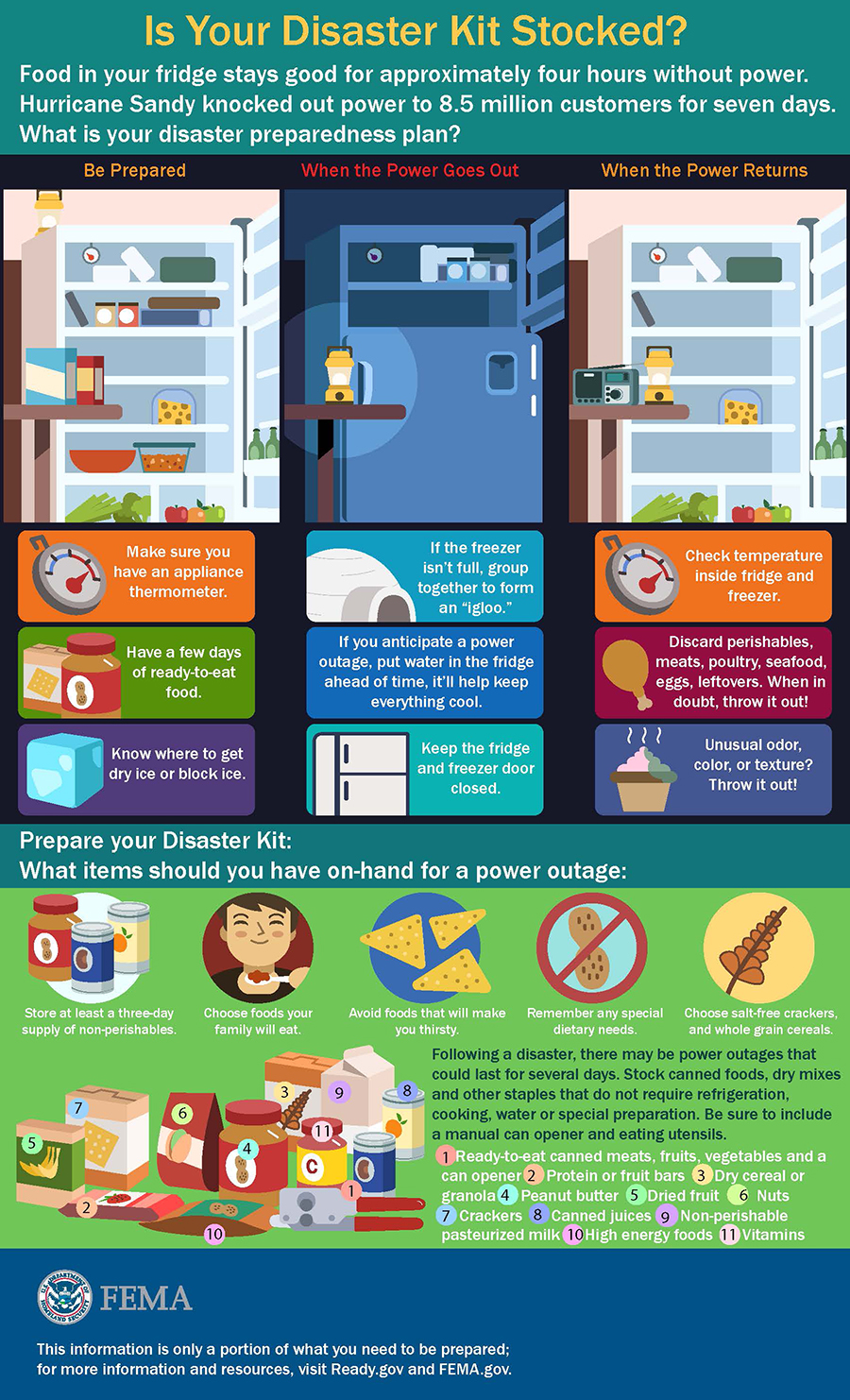
Get a kit - Your disaster kit should have at least three days of nonperishable food and three gallons of water for each person and pet in your home, along with other supplies. Click here to see a disaster guide shopping list.
Stay informed – A tropical system can develop very quickly. Be sure you take time every day to monitor the local media. Escambia County also has several tools available for our residents. Learn more here.
Prep your yard – During hurricane season, it is also recommended that residents take a few minutes to inspect their home and yard. Check for, fix or remove loose items on your home and sheds. Clear loose and clogged rain gutters and down spouts. Learn more here.
Click graphic to enlarge.
Hurricane Closure List
October 8, 2018

Escambia County FL
- Escambia County public schools will be closed a half-day on Tuesday, Oct. 9 and full day on Wednesday, Oct. 10. More info…
- Byrneville Elementary Charter School follows the same closure schedule as Escambia County.
- University of West Florida will close at noon on Tuesday, Oct. 9 and remain closed on Wednesday, Oct. 10. ct. 9 and remain closed on Wednesday, Oct. 10 due to Hurricane Michael. This includes all classes, events, campus activities and online courses.
- Pensacola State College will close at noon Tuesday and remain closed through Wednesday. This closure includes all classes, evening classes, school activities, and online classes.
- All Council on Aging dining sites will be closed Wednesday. Meals on Wheels will not be delivered on Wednesday
- Lighthouse Private Christian Academy will close all their campuses on Tuesday and Wednesday.
- Marcus Pointe Christian Academy will have a noon dismissal on Tuesday, Oct. 9 and remain closed all day on Wednesday Oct. 10.
- Marcus Pointe Christian Preschool and after-school care will dismiss at 4 p.m. on Tuesday, Oct. 9 and remain closed all day on Wednesday, Oct. 10.
- Pensacola Christian Academy is open all day on Tuesday. A decision will be made later about Wednesday.
- The Florida Forest Service is shutting down its operations, offices, recreation and day-use areas in Escambia, Santa Rosa and Okaloosa counties starting Tuesday.
- Century Town Hall will close at noon Tuesday and be closed on Wednesday.
- Santa Rosa County schools will be closed all day on Tuesday, Oct. 9 and extracurricular activities will be complete by noon. Schools will be closed for a full-day on Wednesday, Oct. 10.
- All Council on Aging dining sites will be closed Wednesday. Meals on Wheels will not be delivered on Wednesday
- The Florida Forest Service is shutting down its operations, offices, recreation and day-use areas in Escambia, Santa Rosa and Okaloosa counties starting Tuesday.
- All Escambia County, AL, schools are scheduled to be open on Tuesday. No changes announced for Wednesday.
Escambia County Offers Sand For Sandbag Hurricane Prep
October 8, 2018

Escambia County is offering sand for sandbags for residents living in flood-prone areas. The sand will be available after 9 a.m. and distributed on a first come, first served basis. Residents must bring their own sandbags and shovels to one of the following locations (map):
- Don Sutton Park – 2320 Crabtree Church Road, Molino
- Travis M. Nelson Park – 4541 County Road 4, Bratt
- Escambia County Road Department – 601 Highway 297-A, Cantonment
- John R. Jones Jr. Athletic Park – 555 E. Nine Mile Road
- Equestrian Center – 7750 Mobile Highway
- Ferry Pass Middle School – 8355 Yancey Lane, sand on NW corner of school property on Parazine Street
- Baars Field Athletic Park – 13001 Sorrento Road
- Brent Athletic Park – 4711 N. W St.
When use properly, sand bags can be an effective tool for flooding from a rain event, but not for storm surge. For more information on how to make and use sandbags, visit the Federal Alliance for Safe Homes (www.flash.org). Sand bags can be purchased at most local hardware or home improvement stores, typically for a low cost.
Pictured: Sand made available at Travis Nelson Park in Bratt. NorthEscambia.com file photo.
Escambia Schools: Early Release Tuesday, Closed Wednesday
October 8, 2018

Tuesday will be a half-day early release, and schools will be closed Wednesday in Escambia County, according to Superintendent Malcolm Thomas.
All extra curricular activities are canceled for both days.
Early Dismissal Times:
- All ECSD Elementary Schools will dismiss at 11:00 a.m.
- Middle Schools:
- Brown Barge 12:00 noon
- Ernest Ward 12:35 p.m.
- All other middle schools will dismiss at 12:50-12:55 p.m.
- High Schools:
- West Florida 11:55 a.m.
- Northview 12:10 p.m.
- All other high schools will dismiss at 12:00 – 12:05 p.m.
Although current projections for the storm track for Hurricane Michael indicate that our area may be spared the greatest part of this storm, we are making this announcement now so that parents and staff can prepare,” Thomas said.
Any additional announcements and updates will be posted on NorthEscambia.com.
SANTA ROSA COUNTY:
Santa Rosa Schools will be closed *all day* Tuesday and Wednesday. This is a change from a half day previously announced for Tuesday.
Scott Declares Emergency, State Preps For Michael
October 8, 2018

Gov. Rick Scott on Monday warned residents of the Panhandle and the Big Bend region to “seriously” plan for the impact of the rapidly developing Hurricane Michael, which is expected to reach Florida by mid-week with maximum sustained winds of 100 mph.
“You’ve got to take care of yourself,” said Scott, sporting his faded Navy baseball cap that has become a hallmark of his past emergency attire, after a briefing at the Bay County Emergency Operations Center in Southport.
Scott said emergency officials are “doing everything they can to get everybody ready.” But, as Michael is expected to bring storm surge, rains, flash flooding and tornadoes, Scott said the storm’s northern speed through the Gulf of Mexico is different from hurricanes that have hit Florida the past couple of years.
“This has been different from a lot of the storms we’ve seen since I’ve been governor. It’s fast, this is coming very fast,” Scott said. “It could speed up. It could slow down. We don’t know. And we don’t know exactly where it’s going to hit yet.”
The National Hurricane Center expects Michael to move inland in the Panhandle or Big Bend on Wednesday, and then move northeast Wednesday night and Thursday across the Southeast U.S.
“Steady to rapid strengthening is forecast during the next day or so, and Michael is forecast to become a major hurricane by Tuesday or Tuesday night,” the National Hurricane Center said Monday morning after receiving data from an Air Force Reserve Hurricane Hunter aircraft.
Mark Wool, warning coordination meteorologist for the National Weather Service in Tallahassee, said the storm will be more damaging than Hurricane Hermine, which hit Tallahassee and other areas of the Big Bend in 2016.
“Hermine was a marginal Category 1 storm. We are talking about a significantly higher level of wind,” Wool told The News Service of Florida. “In Hermine, it knocked power out to part of the city (Tallahassee) for a week. There are a lot of trees, not just in Tallahassee, but in all of the surrounding parts of the Big Bend, up into Georgia and over the Panhandle. So, power outages should be expected, and they are going to be of a lengthy duration.”
Wool raised concerns about potential storm surge in Franklin County’s Apalachee Bay, which he described as the “second-most vulnerable stretch of coastline in the entire nation for storm surge, because of the shape of the coastline. It funnels the water right up in there.”
Hermine made landfall in the St. Marks area and moved north through Tallahassee. While it remains unclear where Hurricane Michael will hit, Wool said it would be more powerful than other storms that have damaged the eastern Panhandle and Big Bend.
“There hasn’t been a major hurricane landfall in that part of the Florida coastline since the late 1800s. So, no one alive in this part of the world will have experienced a hurricane of this strength in this part of the state,” he said. “If you think, ‘Oh, I rode out Hermine and I can handle it this time around,’ you might want to reconsider for this one.”
As of 11 a.m. Monday, Michael was about 140 miles east-northeast of Cozumel, Mexico, and 50 miles from the western tip of Cuba.
The storm, moving north at 7 mph, had maximum sustained winds of 75 mph. The National Hurricane Center anticipates the northward motion to pick up through Tuesday night, with a northeast shift expected Wednesday and Thursday.
On Sunday, Scott declared a state of emergency for 26 counties in the Panhandle and the Big Bend, which generally includes areas surrounding Tallahassee.
The state has activated 500 members of the Florida National Guard and has another 5,000 on standby. The Florida Fish and Wildlife Conservation Commission has also designated 40 law-enforcement officers for rapid deployment.
Scott said he also wants local governments to confirm that mutual-aid agreements with electric utilities have been signed so there is no delay in power restoration.
In 2016, Scott clashed with Tallahassee Mayor Andrew Gillum, now the Democratic candidate for governor, over the city’s response to Hurricane Hermine.
Late Sunday, Gillum’s campaign announced he scrapped campaign stops planned Monday and Tuesday in South Florida to return to Tallahassee to “focus on preparing the city of Tallahassee and residents” for the storm.
Gillum’s mayoral office separately sent out a release that said he “reached out to Governor Scott with an update on the city’s efforts.”
Republican gubernatorial candidate Ron DeSantis tweeted that he was redirecting his “Panhandle campaign staff and volunteers to help prepare their communities ahead of the storm.”
Counties along the Gulf Coast were expected to discuss evacuations later Monday.
A hurricane watch, indicating that tropical-storm winds are possible within 48 hours, was in effect from the Alabama-Florida border to the Suwannee River, with a tropical-storm watch extending from the Suwannee River to Anna Maria Island and from the Alabama state line west to the Mississippi-Alabama border.
A storm-surge watch, indicating rising water moving inland within the next 48 hours, is in effect from Navarre to Anna Maria Island, including Tampa Bay.
The National Hurricane Center projected the storm to dump four to eight inches of rain across the Panhandle and Big Bend, with some isolated maximum amounts of 12 inches.
On its current path, Michael could create surges of seven to 11 feet from Indian Pass to Crystal River. The surges would diminish further away from landfall, but even the Florida Keys could get up to four inches of surge.
With agencies preparing for the storm, the Florida Department of Law Enforcement said a meeting this week of the Marjory Stoneman Douglas High School Public Safety Commission had been canceled. The commission, formed after the Feb. 14 mass shooting at Marjory Stoneman Douglas High School in Parkland, had been slated to meet Tuesday, Wednesday and Thursday in Broward County.
Also, Florida State University said in a tweet that it will close Tuesday through Friday.
Hurricane Warning Issued; Michael Strengthening
October 8, 2018

THIS STORY IS OUTDATED. See NorthEscambia.com for the latest information.
Hurricane Michael is expected to intensify prior to landfall on Wednesday as a major category 3 hurricane.
A hurricane warning is now effect for Escambia and Santa Rosa counties.
The latest specifics on Michael in the graphics on this page.
Michael is forecast to move north over next few days and increase in forward speed as it moves between a ridge over the western Atlantic and a trough over the west central U.S. Michael should turn northeast ahead of the approaching trough –the strength and timing of the approaching trough will be a key factor in the turn. Some uncertainty still exists in the degree and timing of this turn and while the forecast cone has shifted slightly east, it is important to remember that impacts can extend far outside the cone, according to the National Weather Service.
The NWS said it is too early to pinpoint what area will see the most impact from the storm.

![[Image of probabilities of 34-kt winds]](https://www.nhc.noaa.gov/storm_graphics/AT14/refresh/AL142018_wind_probs_34_F120+png/024012.png)


Escambia County Urges Residents To Prep And Monitor Hurricane
October 8, 2018

A Hurricane Watch has been issued for the Florida Panhandle, including Escambia County due to Huricane Michael, which is forecast to become a major hurricane before landfall.
Here is the latest information from Escambia County:
It is still too early to determine what direct impacts the Hurricane Michael might have on Escambia County and Northwest Florida, but according to the National Weather Service in Mobile, strong winds, storm surge, flash flood conditions and deadly rip currents are likely across portions of the northern Gulf Coast. Impacts are dependent on the track of this system.
A high risk of rip currents and high surf advisory are in effect for the northern Gulf Coast through at least Thursday. Red flags are flying on Pensacola Beach and are expected through Thursday. Red flags represent high surf and/or dangerous currents, and there is no swimming or wading in the Gulf of Mexico in red flag conditions. Only experienced surfers with a surfboard and leash are allowed to enter the Gulf. Surf heights are forecast to increase to 3-5 feet today, 5-8 feet by Tuesday, and 8-10 feet by Wednesday, according to NWS Mobile.
Escambia County Emergency Management is closely monitoring this system, including participating in weather conference calls with the National Weather Service and state. Residents are urged to do the same by monitoring our local media for the most up-to-date forecasts several times a day. (NorthEscambia.com will have the latest storm information posted 24/7.)
Residents should also take the time now to double check their storm supplies and preparations so that if and when a confirmed threat develops, they are ready. The key to reducing the stress and impact on your family is to prepare by taking the following steps:
Review or make a family plan. This includes:
- Knowing your evacuation zone is one of the most important hurricane preparation steps you can take. It is very important that you look up your evacuation zone each year to find out if and when you should evacuate, even if you have looked it up in the past, as zones can change. Most importantly, don’t rely on previous storm experience. Just because you weathered the last storm, doesn’t mean you will weather this one. Look up your address online at myescambia.com/knowyourzone.
- Know where you will go. If you live in an evacuation zone, know where you will go and how you will get there. Will you go to a friend or relative’s home, a hotel, or as a last resort, a public shelter? It is always easier to go tens of miles, not hundreds. Find a list of shelters, including special needs and pet-friendly, here.
- Have a communication plan. Plan now how you will contact one another and where you will meet.
- Plan for those with special needs. Make arrangements in advance to accommodate those in your family with special needs like the elderly, children and pets. Always have at least an extra 3-10 days stock of medical supplies, medication and any other special items you may need.
- Understand Watch vs. Warning, the hurricane cone and what steps you need to take when. Learn more by clicking here.
- Take photos of important documents and your valuables. Save these to a secure cloud site, thumb drive or keep on your mobile device.
Get a kit - Your disaster kit should have at least three days of nonperishable food and three gallons of water for each person and pet in your home, along with other supplies. Click here to see our latest disaster guide shopping list.
Stay informed – A tropical system can develop very quickly. Be sure you take time every day to monitor the local media. Escambia County also has several tools available for our residents. Learn more here. Monitor local media and legitimate online and social media sources like Escambia County Emergency Management, US National Weather Service Mobile, NOAA NWS National Hurricane Center and Florida SERT.
Prep your yard – As we are entering hurricane season, it is also recommended that residents take a few minutes to inspect their home and yard. Check for, fix or remove loose items on your home and sheds. Clear loose and clogged rain gutters and down spouts. Trim trees and shrubs around your home. Learn more here.
ECSO: Two Arrested With Drugs And Counterfeit Cash
October 8, 2018

Two North Escambia men were arrested for allegedly possessing drugs and counterfeit cash.
The Escambia County Sheriff’s Office responded to a gas station on Michigan Avenue where they found Travis Winters asleep in the driver’s seat of a pickup truck at the gas pumps.
After deputies removed passenger Hunter Manning from the vehicle, the report states deputies located a syringe containing heroin in his pocked and a straw containing methamphetamine, according to an arrest report. Deputies also found marijuana and heroin inside a cigarette pack that they saw Manning reach for inside the vehicle.
The arrest report states Winters had been sitting on a bag containing counterfeit $100 bills and methamphetamine. They also reported finding a counterfeited $100 bill in his pocket.
Manning, age 26 of Cantonment, was charged with possession of methamphetamine, three counts of possession of heroin, possession of marijuana, three counts possession of drug paraphernalia, resisting an officer and possession of counterfeit money. He was released on $13,500 bond.
Winters, age 21 of McDavid, was charged with possession of a methamphetamine and possession of counterfeit money. He remained jailed Monday without bond.
FWC Law Enforcement Report: Pet Deer, Palmetto Berry Pickers
October 8, 2018

The Florida FWC Division of Law Enforcement reported the following activity during the period ending September 20 in Escambia and Santa Rosa counties.
ESCAMBIA COUNTY
 Officers Manning and Allgood patrolled offshore concentrating on fisheries enforcement utilizing the newly arrived Safe Boat in Pensacola. They found occupants from five different vessels in violation of federal fisheries regulations. Five federal citations were issued for charges including possession of triggerfish during closed season and for possession of red snapper in a closed season. The officers also charged one vessel operator with interference with an FWC officer for attempting to throw illegally harvested triggerfish and red snapper overboard.
Officer Allgood assisted FWC captive wildlife investigators with a subject who was attempting to keep a whitetail deer as a pet. Officer Allgood issued a citation to the subject who was keeping the deer in an enclosure. The individual had previously applied for a permit but was denied.
SANTA ROSA COUNTY
Officers Hoomes, Roberson, Ramos, Hutchison and Pilot Tolbert have been working a ring of illegal palmetto berry pickers on Eglin Wildlife Management Area (WMA). The officers found evidence of the illegal activity and caught up with four subjects who had picked over 600 pounds of palmetto berries from Eglin WMA. All four subjects were cited for 13 misdemeanors which included harvesting live plants from a management area, entering a closed area, and no Department of Defense permit. One subject, who fled but was later located, was cited for resisting arrest without violence.
This report represents some events the FWC handled over the past week; however, it does not include all actions taken by the Division of Law Enforcement. Information provided by FWC.
NorthEscambia.com photo.