TS Gordon: Local Escambia County Info
September 4, 2018
Here is the latest Escambia County information on Tropical Storm Gordon:
Essential Local Information
- Residents are asked to stay off the roads on beginning Tuesday afternoon if possible, as wind gusts and flash flooding may cause serious road hazardous.
- With Gordon’s wind field enlarged, the potential for bridge closures has increased. It is highly recommended that if bridges are part of your travel, that you make your way to your evening destination by 4 p.m., Tuesday.
- Board of County Commissioner offices will closed at 2 p.m. except for essential personal and those with bridge crossings in their commute.
- No evacuations are being called for at this time.
- No shelters are currently being opened, however the American Red Cross is on standby if the need arises.
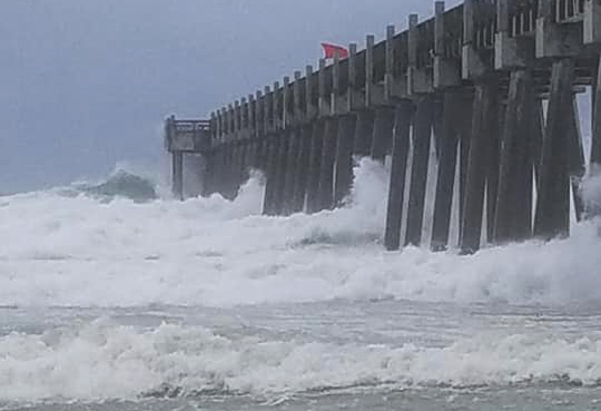
- Red flags are currently flying on Pensacola Beach. In Escambia County, except for surfers with a leash, it is illegal to enter the Gulf of Mexico when red flags are flying. Dangerous rip currents can also be present in yellow flag conditions. Learn more here.
- The emergency operations center is currently at a level 3, or monitoring, and all essential staff are ready to respond as needed.
Storm Information From NWS
- A tropical storm warning remains in effect for Escambia County.
- Tropical Storm Gordon is still forecast to intensify to a minimal hurricane prior to landfall on the north central Gulf. Landfall likely this evening on the Mississippi Coast.
- Deteriorating conditions with heavy rain and tropical storm force winds along the immediate coast beginning midday.
- Most likely arrival of tropical storm force winds will be this afternoon along the coast and this evening/tonight inland.
- Expect bands of rain and winds starting in the afternoon and diminishing by early Wednesday morning.
- A storm surge watch continues, with 1-3 feet of inundation. The greatest risk of storm surge will be this evening into early Wednesday morning and the water levels will be slow to recede due to onshore winds.
- Rainfall amounts of 3-5 inches, with localized higher amounts up to 6-10 inches possible
- Expect multiple rounds of heavy rain, creating flash flood conditions. Our area is under a flash flood watch.
- Brief tornadoes are possible in the rain bands.
- Dangerous surf conditions continue.
Sand Bags
Escambia County is offering sand for sand bags for residents living in flood-prone areas. The sand will be distributed on a first come, first served basis. Residents must bring their own sandbags and shovels to one of the following locations (map):
- Baars Field Athletic Park – 13001 Sorrento Road
- Brent Athletic Park – 4711 N. W St.
- Don Sutton Park – 2320 Crabtree Church Road
- Equestrian Center – 7750 Mobile Highway
- Escambia County Road Department – 601 Highway 297-A
- Ferry Pass Middle School – 8355 Yancey Lane, sand will be on the northwest corner of school property on Parazine Street
- John R. Jones Jr. Athletic Park – 555 E. Nine Mile Road
- Travis M. Nelson Park – 4541 County Road 4
When laid properly, sand bags can be an effective tool for flooding from a rain event, but not for storm surge. For more information on how to make and use sandbags, visit the Federal Alliance for Safe Homes (www.flash.org). Sand bags can be purchased at most local hardware or home improvement stores, typically for a low cost.
Military
- Naval Air Station Pensacola, Corry Station and Saufley Field will curtail normal operations and close to all visitors and non-essential personnel at 7 a.m., Sept. 4. All employees should contact supervisors for specific information.
Power Outages
- Please do not call 9-1-1 to report power outages.
- Gulf Power knows when your power is out. You can track outages on their outage map from your smartphone: at outagemap.gulfpower.com
- Report outages to Escambia River Cooperative, Inc at 1-877-OUT-EREC or 1-877-688-3732 and view the EREC Outage Map.
- Never touch a fallen power line and assume all wires on the ground are electrically charged.
Schools
- Escambia County Schools are closed Tuesday, Sept. 4.
- The University of West Florida are closed Tuesday, Sept. 4.
- Pensacola State College are closed Tuesday, Sept. 4.
- Pensacola Christian Academy classes are canceled for Tuesday, Sept. 4. Afternoon and evening activities are also canceled. Pensacola Christian College classes WILL meet on Tuesday.
Pensacola Beach Fishing Pier
- The fishing pier is closed until further notice.
City of Pensacola Parks
- All city of Pensacola Parks and Recreation Neighborhood Resource Centers will be closing at 5 p.m. on Tuesday, Sept. 4. Osceola Golf Course, Roger Scott Tennis Center, and Pensacola Athletics will make decisions individually based on weather conditions at the appropriate times and will be posted on www.playpensacola.com.
Gulf Island National Seashore
- Gulf Islands National Seashore at Ft. Pickens, Perdido Key, and Opal Beach Day use will close at 10 a.m. Tuesday, Sept. 4.
Road Closures
- Gulf Islands National Seashore officials will close Hwy. 399/J. Earle Bowden Road between Pensacola Beach and Navarre Beach today at 4 p.m. ahead of Tropical Storm Gordon.
- Any closures will be announced as they occur.
- Bridges will be closed at the onset of sustained tropical storm force winds, or 39 MPH.
- Windy conditions adversely affect all vehicles, particularly high profile vehicles, such as buses and trucks, as well as motorcycles. Gusty winds make driving difficult, especially when it is rapidly changing speed and direction.
- Heavy rain may quickly flood low-lying areas including roads and bridges. Standing water creates a serious road hazard, even when only a portion of the roadway is flooded.


Comments