NWS: Molino Tornado Was EF-0 (With Path Map)
April 24, 2018
The National Weather Service has officially determined that it was an EF-0 tornado with winds peaking at 85 mph that caused damage in Molino Sunday afternoon.
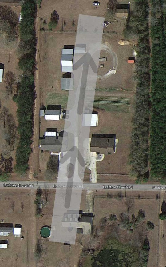
The EF-0 tornado traveled in a southerly direction 0.13 miles across Crabtree Church Road over a one minute period — from 1:02 to 1:03 p.m. The tornado’s path was 25 yards wide. (See approximate map below.)
According to the National Weather Service, one home suffered shingle damage and a broken window and a mobile home was shift on its foundation (both pictured below). There were also several uprooted small trees and numerous large branches broken.
The map below shows the starting and end point of the EF-0 tornado in Molino. The highlighted area depicts the maximum width of the tornado path, according to the National Weather Service. Damage was not necessarily confined to the area inside this path.
For earlier stories click here and click here.
For a photo gallery, click here.
For two videos of the tornado, click here.
NorthEscambia.com photos and graphic, click to enlarge.
Comments
2 Responses to “NWS: Molino Tornado Was EF-0 (With Path Map)”


>>Note…It started on Sunshine Hill Rd.abt 7000 Blk. Tore down fence & other small damage.
The “path” as found by the NWS is above. That’s not to say damage was not done outside and near the path.
Note…It started on Sunshine Hill Rd.abt 7000 Blk. Tore down fence & other small damage.