Engineers, Lawmakers Look For Answers On Hwy 29 Flooding
June 11, 2013
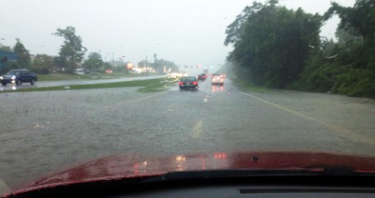
Thousands of people were inconvenienced Monday when just four inches of rain closed Highway 29 both north and south bound for over eight hours. And it left state highway officials, engineers and lawmakers scrambling for answers as to how a relatively normal heavy rainfall could paralyze the major north-south hurricane evacuation route from Pensacola.
“If this were a hurricane and four inches of rain had closed the highway, it would be a major cause for concern,” Ian Satter, spokesman for the Florida Department of Transportation said. “But fortunately it was not, and this will give us a chance to figure out what happened.
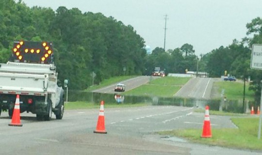
Highway 29 and its associated drainage system are designed to handle heavy rainfall and remain open. Satter said state officials responded to flooding across Highway 29 just north of East Kingsfield Road and went to work looking for the reason the drainage system had failed. He said there was not an immediately apparent problem on state right of way, and state officials were awaiting word from county officials about the drainage on their right of way for Highway 95A and railroad officials about drainage on their adjacent right of way.
But as of late Monday afternoon, there was no word on what went wrong and led to the poor drainage and flooding.
Meanwhile, state lawmakers were looking for answers and pledging their support to help FDOT alleviate the problem.
“It is essential that Highway 29 remain clear and open. This is especially important during hurricane season because of the fact that Highway 29 is part of the evacuation route from the coast. Today, I spoke with District 3 FDOT Secretary Tommy Barfield and we discussed the flooding that forced the closure of the road,” State Rep. Clay Ingram told NorthEscambia.com. “Knowing that drainage issues have been a problem in the past, he is putting an action plan in place which includes sending drainage engineers here immediately to determine the best way to deal with the water. I will stay in close contact with FDOT to make sure that that this problem is addressed.”
In Sen. Greg Ever’s office, aide Dave Murzin said the senator’s office reached out to FDOT Monday and offered to send a representative to the site to assist the in the evaluation. “We are willing to help however we can to help make sure this does not happen again,” Murzin said.
Pictured top: This reader photo by Jamie Boutwell shows water crossing Highway 29 before the roadway was closed Monda morning. Pictured below: Reader photo by Brandi Ratcliff shows Highway 29 closed at East Kingsfield Road. Submitted photos for NorthEscambia.com, click to enlarge.
Comments
20 Responses to “Engineers, Lawmakers Look For Answers On Hwy 29 Flooding”


why dont they just put large colvert pipes in , and raise the road , most efficent solution. ooohhhh I forgot, its Escambia County, they want to wait for at least 3 maybe 4 deaths frim this site, before acting on this
Blame it on the beavers. Problem solved.
My husband and I have discussed this issue a few times, each time it has happened. He said he remembers it happening all the time when he was in high school at Tate (in the 80’s) in that spot (and sometimes the Old Chemstrand intersection) whenever there was heavy rainfall. Sorry, but the new businesses are not to blame.
In response to…aresident on June 11th, 2013 3:36 pm
I wonder how much this had to do with the construction from the new waffle house, and sonic, etc, because if I remember right, this has only been a major issue for the past 4 years or so
And HOW Long have you lived here????
The intersection of Old Chemstrand rd & 29 was under water many years ago… This problem was way before there was anything but the corner store and Barbar shop…
I say build a large holding pond like 9 mile rd.& 8 mile – It has not flooded there in years….As it did in years past.
That’s why Florida DOT should be designing another alternative northern route such as I-65 connector from I-110 spur. Our county has less than 100.000 vs Mobile County yet our DOT Officials will not push for a federal I-65 connector.Federal Government is offering funding for infrastructure so why want Florida DOT tap into it. South Florida is always building alternative routes.Why want Florida DOT apply for funding and construct building an I-65 Connector?
Ahh….. This has been happening at this spot for 20+years. This shouldn’t be a mystery to our state engineers.
There are two hills on either side of the flooding my guess is that since water can’t flow uphill it has to stay at the bottom of both hills and thus cause flooding.
It flooded the same way last June and again in March 2009. The only difference in 2009 was that only the northbound traffic was affected. Neither of those events were relayed to the FDOT or FHP. Only local LEO’s were used to reroute traffic. Those events only lasted an hour or so.
When the inmate crews where working they kept the drainage clear of debris and right of ways clean, but someone thought it be better to pay a contra
ctor a lot more money and get less work done.
I wonder how much this had to do with the construction from the new waffle house, and sonic, etc, because if I remember right, this has only been a major issue for the past 4 years or so
From the photo it looks like about a 6 1/2 year study to determine if it was less than adequate drainage or the amount of rain that caused the flooding.
Following that there will be a 9 year road re-build project during which traffic will be rerouted to a single lane while the flooded section of highway is raised up.
@ Richard Turley, agreed, invoice to follow.
FDOT will study the traffic pattern and vehicle count for a few months and recommend a traffic light installed at the lowest point of water collection area. The 2014 super traffic control with digital camera built- in will Automatically activate the flashing yellow during a flood. Problem solved. Invoice to follow.
It is called “not keeping the culverts/ditches and creeks clear of debris”.
>>>>This happens at least once a year in the same location about the same time a year.
Can you please tell us when Hwy 29 northbound and southbound were both last closed here due to flooding ALL DAY? Nobody else seems to remember this and FDOT and the FHP have no record of it either.
This happens at least once a year in the same location about the same time a year. Just heavy rainfall.
It’s called Flash Flooding and it happens in a flash. Water runs down hill every time and when your at the bottom of the hill, flooding occurs. Amazed how its takes inconvenienced voters…oops, I mean Taxpayers to gather a delegation of engineers to talk about it. The main engineering factor is less places for all the water to percolate through the soil structure. The limiting factors are concrete, curbs, parking lots, hard compacted surfaces in a small areas that results in no place for the water to move except fast to the lowest point. Find a lower point to move the water to, but the problem remains.
As DHG would sign off and say, ” dumb country boy for more subdivisions per square mile”
theres a swamp behind the rroad off kingsfield,the water comes under the rroad,theres ,,a lift station on kingsfield , block the drain under the rroad,pump the water into the sewer,.walla,
Just a willlld guess-tree down across creek somewhere, catches debris washed there by rain??????????????????????????????
Hwy 95A was looking good. Water goes west here,away from 95A.
Typical for the State and Transfield to not take responsibility for State R/W.
Raise The Road Or Put In A Bridge.