Magnolia Branch Honored As Treasure Forest (With Video)
March 18, 2013
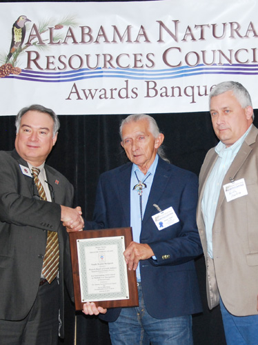
The Poarch Band of Creek Indians recently received the Helene Mosley Memorial TREASURE Forest Award for the South Region at the Alabama Natural Resources Council’s Awards Banquet in Auburn.
The event recognized PCI for exemplary dedication to the wise stewardship of natural resources at the Magnolia Branch Wildlife Reserve. (For more information about Magnolia Branch, see the video at the bottom of the page.)
 PCI has earned many honors for their forest stewardship. In June 2010, they received three prestigious awards for forest management activities at MBWR: the Alabama Natural Resources Council’s TREASURE Forest Award and certifications for the Forest Stewardshipand the American Tree Farm Programs. This was the first time a landowner had received all three recognitions at the same time.
Magnolia Branch is mostly timberland and is used as a recreational area for the Tribe and their guests. By working with various state and federal agencies, the Tribe has sustained, protected, and enhanced 6,000 acres of timberland and 50 lakes. PCI partnered with USDA’s Natural Resources Conservation Service (NRCS) and the U.S. Fish and Wildlife Service (USFWS) to secure financial and technical assistance for site preparation on about 800 acres planted to longleaf pine, and to install permanent firebreaks and prescribe burn over 2,000 acres of pine plantation.
“Managing for timber is vital to our long-term forest goals. Seventy percent of our forest land is loblolly and 30 percent has been converted to longleaf pine,” said Billy Smith, PCI Tribal elder and manager of the Magnolia Branch Wildlife Reserve. “Whenever we clear-cut an area of loblolly, we plant it back to longleaf pine. Right now we have planted about 800,000 longleaf pines on Tribal land.”
Prescribed burning plays an important role in the longleaf pine ecosystem. It helps control disease and reduces competition of undesirable understory. It also provides wildlife habitat benefits by stimulating the growth of native plants for wildlife food.
“We are on a two year burn cycle and try to burn about 2,000 acres each year,” Smith said.
The wildlife accomplishments include planting 37 acres of food plots to cool and warm season forages, building numerous wood duck boxes and bird houses, and thinning 2,000 acres to improve wildlife habitat.
They are attempting to reestablish native grasses. “After clearing the understory through a controlled burn, we are seeing the comeback of native grasses that have been here all along,” said Smith.
Magnolia Branch is located south of I-65 west of Highway 113.
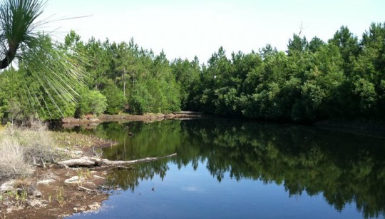
Pictured top: The Magnolia Branch Wildlife Reserve. Pictured inset: Tim Albritton/ NRCS state forrester; James W. (Billy) Smith, general manager of Magnolia Branch Wildlife Reserve; and Keith Martin, Poarch Creek Indian Tribal Council member. Courtesy photos for NorthEscambia.com, click to enlarge.
Comments
7 Responses to “Magnolia Branch Honored As Treasure Forest (With Video)”


this is a wonderful place to go and ride your horses. Billy Smith has always shown a willingness to take suggestions and work with you to make Magnolia friendly for all users. it is one of the few places that you can ride your horses in the water and away from any traffic in this area. the PCI built a very nice stalling area just so that if you want to stay and camp with your horses they also will be taken care of. i just cant say enough about how wonderful it is to have a safe and traffic free place to enjoy nature by horseback.
thank you.
It would be nicer had they not closed off the only place to go lay out at the creek with friends and family. I refuse to pay for something God created
@Friction(>)Machine, It is possible but be prepared to portage around log jams and over shallow places, depending on the rain fall. You have a monster log jam at Cotton lake. I would recommend pulling out at the hwy 31 bridge in Flomaton.
Remember those satillite mosaics are not in real time and are dated. A big rain may have created a jam since the images were made. I would suggest being in shape as you get to dragging or carrying a canoe and gear through 100 degree/90% humidity heat, down through the bushs, a cardiac event could surely happen?
What would be really cool would be putting in somewhere above 65 and taking Big Escambia to Escambia River and on down to Pensacola Bay….I have looked at this from satellite photos…Anyone know if its even possible?
Loved this video! Feel like I’ve been on a mini vacation after watching it!
I think that the Box Turtle habitat is a wonderful idea.
It would be nice to see a canoe/kayak drop point above I-65 as stopping along the interstate is a little hazardous, due to high speed traffic.
The PCI have done so very much for ESC/ALA and it’s surronding areas.
WTG Mr.Billy, this is a wonderful place that you have here for the community as well as visitors to the area. I personally love spending our summers out here with our family and friends camping, tubing and just being in the outdoors. You can count on me, my friends and all my children,nieces and nephews returning in May. Thanks for all that you are doing to give our younger generation a place to enjoy the summers and learn about nature. Get the Camper ready because I know we will be putting it to great use as usual.