

Latest Headlines
- Highway 97 Crash Claims One Woman’s Life, Injures Two Others
- Elected Or Appointed School Superintendent? Referendum Approved By School Board
- Gonzalez Utilities Issues Boil Water Notice For Some Areas West Of Highway 29
- Suspect Charged With Murder Of Man Found Shot And Lying In On McDavid’s Main Street
- Tate High Principal’s Secretary Jackie Barth Named District Employee Of The Month
- Atmore Mayor Jim Staff Announces Retirement
- ECSO Coffee With A Cop Thursday Morning At The Parking Latte
- FCA Above The Rim, Beyond The Goal Awards Presented To Local Athletes
- 50th Annual Walnut Hill Ruritan Farm Auction Is Saturday
- 1A Northview Lady Chiefs Fall To Defending 6A State Champion Pace

Hurricane Season: Storm Surge Evacuation Zone Map Change
June 1, 2011
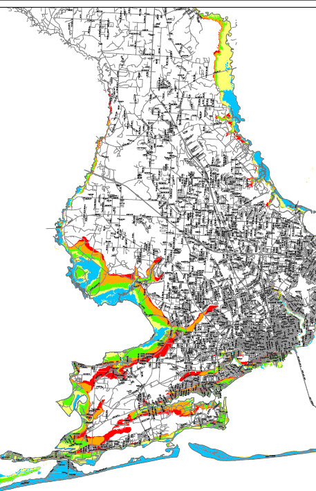 New hurricane evacuation zones in Escambia County reach inland all the way to the North Escambia area. And as the 2011 storm season begins, Escambia County Emergency Management is encouraging residents to check their property on the updated storm surge evacuation zone map.
The old evacuation zones stretched as far north as just north of Nine Mile Road along the Perdido and Escambia Rivers only for category 3 or greater storms. The new evacuation zones stretch as far north as North Barth Road along the Escambia River and Vantage Road on the Perdido River — locations that are prone to flooding.
“Property owners impacted by the new storm surge maps should consider the purchase of flood insurance. Please check with your insurance agent if you are now in an evacuation zone. Staying safe from surge flooding is easy if you follow evacuation orders and don’t wait until it is too late,” said John Dosh, Escambia’s emergency management chief.
The new plans will eliminate evacuation zone references based up the category of the storm. Rather than the category evacuation zones, the county will instead identify evacuation zones with an A, B, C, D, and E reference.
While the new evacuation zones stretch further inland into North Escambia based upon storm surge date, the overall number of people that would be ordered to evacuate will be reduced — most of the included land in the North Escambia area is along the Perdido or Escambia River and very sparsely populated.
To view the new evacuation zones, visit click here.
Comments