

Latest Headlines
- Wrongful Death Lawsuit Filed In 2024 Log Truck, Propane Truck Crash That Killed Molino Girl
- Sunny And Cool Friday
- Cantonment Man Charged As ‘Super Speeder’ For 102 MPH On Highway 29
- West Highway 4 To Close Near Highway 97 Next Week
- Ascend Cares Delivers Christmas Magic To Escambia Westgate Students
- Commemorative 250th U.S. Anniversary License Plates Available In Florida
- Escambia Man Pleads Guilty To Possession Unregistered Machine Gun
- Tate Junior Mykamia Padgett Commits To D1 ASU Softball
- At Least One Injured In Four-Vehicle Highway 29 Crash
- Convicted Cantonment Felon Sentenced On Federal Armed Drug Distribution Charges

New Map Shows Updated Hurricane Evacuation Zones
May 11, 2010
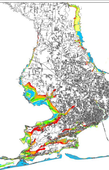 A new interactive map shows new hurricane evacuation zones in Escambia County that reach inland all the way to the North Escambia area.
The Escambia County Division of Emergency Management has worked with the County’s Development Services Bureau planning staff, Geographical Information Services Division, Office of Transportation and Traffic Operations and the West Florida Regional Planning Council to derive new, more refined evacuation zones for Escambia County based upon news storm surge data estimates from the state.
“Zoning changes may affect flood insurance requirements for homeowners in these areas. Please check with your insurance agent now if you are in an evacuation zone,” said John Dosh, Escambia’s emergency management chief.
To view the new evacuation zones, visit click here.
The old evacuation zones stretched as far north as just north of Nine Mile Road along the Perdido and Escambia Rivers only for category 3 or greater storms. The new evacuation zones stretch as far north as North Barth Road along the Escambia River and Vantage Road on the Perdido River — locations that are prone to flooding.
“The new map reduces the overall size of evacuation zones, while more accurately depicting low-lying areas,” Dosh said.
The new plans will eliminate evacuation zone references based up the category of the storm. Rather than the category evacuation zones, the county will instead identify evacuation zones with an A, B, C, D, and E reference.
While the new evacuation zones stretch further inland into North Escambia based upon storm surge date, the overall number of people that would be ordered to evacuate will be reduced.
“In turn, this may reduce the financial burden and hardship that evacuations bring to local businesses and citizens that will no longer need to evacuate,” Escambia County Fire Chief Frank Edwards wrote in a memo to the Escambia County Commission.
Residents that are in the new evacuation zones have received, or will soon receive, a postcard in the mail during the month of May.
Comments
2 Responses to “New Map Shows Updated Hurricane Evacuation Zones”
The color surrounding my property is pinkish-purple – does not correspond to any of the colors listed for surge or evacuation zones. Also, is there any information on the site as to which zones are mandatory evacuation zones ?
Nifty map but I couldn’t see any color “key” so it’s impossible to tell what’s what.