

Latest Headlines
- West Roberts Road $4.6 Million Drainage, Widening Project Begins
- Tate High’s Kristin Maum Is In The Running For ‘America’s Favorite Teacher’
- State Fire Marshal Investigating Early Morning Milestone Fire
- New Leads Emerge In Case Of Molino Man Believed To Be Murdered 20 Years Ago
- One Airlifted After E-bike Incident In Cantonment
- Tate High School Cheerleader Alexis Hudson Signs With University of South Florida
- Century 14U Blackcats Take Second In Escambia/Santa Rosa Tournament
- Century Reports Raw Sewage Spill At Apartment Complex
- Fast Start, Strong Relief Give Blue Wahoos Series Win Over Biscuits
- AAA: Florida Gas Prices Trend Lower Again

New Hurricane Evacuation Zones Include Parts Of North Escambia
April 10, 2010
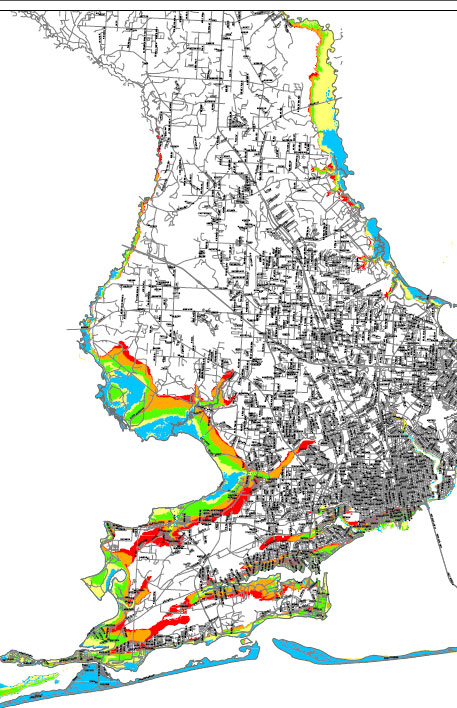 There are new hurricane evacuation zones in Escambia County that reach inland all the way to the North Escambia area.
The Escambia County Division of Emergency Management has worked with the County’s Development Services Bureau planning staff, Geographical Information Services Division, Office of Transportation and Traffic Operations and the West Florida Regional Planning Council to derive new, more refined evacuation zones for Escambia County based upon news storm surge data estimates from the state.
The old evacuation zones stretched as far north as just north of Nine Mile Road along the Perdido and Escambia Rivers only for category 3 or greater storms. The new evacuation zones stretch as far north as Molino Road along the Escambia River and Perdido Lake Road on the Perdido River — locations that are prone to flooding.
The new plans will eliminate evacuation zone references based up the category of the storm. Rather than the category evacuation zones, the county will instead identify evacuation zones with an A, B, C, D, and E reference.
While the new evacuation zones stretch further inland into North Escambia based upon storm surge date, the overall number of people that would be ordered to evacuate will be reduced.
“In turn, this may reduce the financial burden and hardship that evacuations bring to local businesses and citizens that will no longer need to evacuate,” Escambia County Fire Chief Frank Edwards wrote in a memo to the Escambia County Commission.
Residents that are in the new evacuation zones will receive a postcard in the mail during the month of May.
To download a zoomable pdf with both the old and new evacuation maps, click here. (This is large 3.7 Mb file.)
Comments