

Latest Headlines
- Tate Senior Gage Coates Wins Esports Madden NFL Championship
- I-10 To Be Resurfaced From State Line To Near Highway 29 In $19.8 Million Project
- Hundreds Attend Annual Molino Christmas Parade (With Gallery)
- Sheriff’s Office Issues Warning About Warrant, Bond, And Ticket Scams
- University of West Florida Holds Fall Commencement (With Photo Gallery)
- 30,000 Wreaths Placed At Barrancas Cemetery During Wreaths Across America Program
- Quintette Community Center Holds Annual Senior Citizens Christmas Luncheon
- Escambia Man Convicted Of 2022 Murder
- Christmas Parade Rolls Through Century (With Photo Gallery)
- Escambia Sheriff’s Office Hosts Movie Night (With Gallery)

Highway 31 Closed Between Atmore And Perdido
February 8, 2010
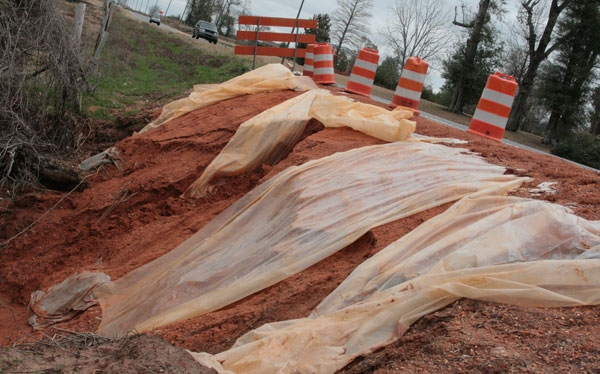
Highway 31 was closed Monday for about a month between Atmore to Perdido.
The road was closed to repair damage from heavy rain and flooding back in December, including an area near Pineville Road. The detour route will be Industrial Drive in Atmore to Jacks Springs Road to I-65 to Baldwin County Road 47 (the Perdido exit) back to Highway 31.
The Alabama Department of Transportation is advising motorists that there could be delays due to the detour, and travel times should be adjusted accordingly.
Weather permitting, the project should be completed by March 12.
Pictured above: Highway 31 was closed between Atmore and Bay Minette for about a month so areas such as this washout in Nokomis can be repaired. The map below pinpoints the location of the photograph above. NorthEscambia.com photo, click to enlarge.
Comments
5 Responses to “Highway 31 Closed Between Atmore And Perdido”
James Rd. is the easiest way to go. There is a road across the street from the new housing complex they built not too long ago. Cross the tracks and follow that road all the way down. It will take you back to 31 by Mr.Green Jeans.
As you know this is a US and State Highway. ALDOT must insure that the route used for a detour is constructed to handle the expected traffic count and the expected vehicle size. While James Rd. is shorter and undoubtedly will be utilized by many locals during this road closure, it does not meet the criteria for a State or US route. The liability would be too great for ALDOT to detour traffic on that route. The road bed, road surface, bridges, and drainage structures may not hold up to the added load. The citizens (especially children) that live on James Rd. would also be in a more dangerous situation with the added traffic.
While there will be some inconvenience using the stated detour route, ALDOT used the best overall route for the safety of the motoring public.
Thanks, Northview HS parent I agree. This map makes no sense at all. James Road is definitely your best bet and is only 2 minutes out of the way.
James road sometimes has a train parked across it.
I don’t see why they don’t just detour the traffic around on James Road. As anyone can see from the map, and many locals know, James Road makes a loop that goes around the work area.