Residents Watch Funnel Cloud Track Into North Escambia
April 2, 2009
A National Weather Service forecaster says the public played a critical role in tracking a funnel cloud as it tracked into North Escambia last Tuesday afternoon.
“This event illustrates just how essential accurate ‘ground truth’ public reports can be to the operations of the NWS” said Jeffery Medlin, a forecaster at the National Weather Service in Mobile.
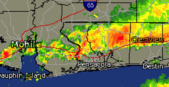
About 5:35 Tuesday afternoon, the NWS received several reports of a funnel cloud forming near the landfill in Beulah. Many ordinary citizens and law enforcement officers witnessed the funnel cloud along its path from Beulah to just southeast of Cottage Hill. The weather service immediately issued a tornado warning in the area.
The funnel cloud never touched down, and there were no damage reports.
“Miraculously,” Medlin said, “the rotating funnel cloud never evolved into a tornado along its path.”
As for the official reason why the funnel cloud never formed a tornado, Medlin said “a rain-cooled outflow boundary was observed on radar to have surged south of the I-10 corridor after earlier heavy rains to the north. Although the thunderstorm updraft that produced this funnel formed on this boundary…the stable rain-cooled air essentially undercut the base of The Funnel…and points further to the north…effectively preventing it from contacting the ground as a tornado.”
Pictured above: The radar as a funnel cloud was forming near Beulah Tuesday afternoon.
Comments
3 Responses to “Residents Watch Funnel Cloud Track Into North Escambia”


Where there is lightning there is bound to be thunder.
The weather continues to amaze me on this site. We are so fortunate to have this. One more comment ,If somehow we could get the grocery flyers I know a lot of people that could cancel subscriptions to three local newspapers.
I thank The Lord for answered prayers. Cooling a cloud is an easy thing for Him to do, but believe that prayer moves Him to act. We have not, because we ask not, more times than we know.