

Latest Headlines
- Century Now Has New Interim Mayor; Town Seeks New Interim Council Member
- Casey’s Seeks Variance For New Molino Convenience Store At Highway 29, Highway 97
- Early Morning Crash Claims Life Of Motorcyclist In Escambia County
- Minor Injuries In Three Vehicle Crash Involving School Bus In Cantonment
- Escambia Commissioners Pick Developer And $50 Million Offer For OLF-8
- Escambia County’s Graduation Rate Increases As State Breaks Record
- Escambia Sheriff’s Office Updates Cruiser Paint Scheme
- Walnut Hill Man Charge With Battery Of 65-Year-Old Relative
- Spirit Airlines Adding Spring Break NonStop Pensacola Flights To Chicago, Dallas, Detroit, Nashville
- Century Felon Facing Local Gun Charges After Visit From U.S. Secret Service

Flooding: When Does The Escambia River Flood Century, McDavid And Molino?
April 8, 2009
We have all heard and read the reports about flooding on the Escambia River after our recent heavy rainfall. But what do those reports mean for residents of Century, McDavid and Molino? What would happen in those areas if the river had continued to rise? Would it be a cause for concern?
Perhaps…the Great Flood of 1929 caused major problems as the areas around Flomaton, Century, McDavid and Molino were flooded. But since then, the Escambia River has failed to reach the level that the National Weather Service terms “moderate” flood stage.
Flood stage on the Escambia River is 17 feet, and moderate flood stage is 25 feet — a number the river level has only reached once in recorded history.
On March 15, 1929, the Escambia River reached its record level of 37.8 feet. Otherwise, the river has never reached that moderate flood stage level, according to records from the National Weather Service Advanced Hydrologic Prediction Service. It has come close, reaching 24.24 feet on March 18, 1990. There have been three other Escambia River crests over 23 feet — two in 1998 and once in 1975.
Here is a complete look at what happens along the Escambia River in North Escambia at various water levels:
- 17.0 — considerable flooding of lowlands will occur.
- 17.5 — some flooding of lowlands in the area will continue until the river level drops below 13 feet.
- 19.0 — low lying pastures will flood and cattle should be moved to higher ground.
- 19.5 — flooding of farm and pasture lands will gradually subside as the river level drops…but some flooding will continue the next several days.
- 23.0 — widespread flooding of pasture and farm lands in the area will continue. water begins to reach Mystic Springs Road, Worley Road, Bamer Holley Lane and River
- Bend Road. Approximately five homes become isolated in the Mcdavid and Molino areas. Public boat ramps at Mystic Springs and Fairground Road are submerged.
- 23.7 — second highest flood of record. Approximately eight homes become isolated and sections of Mystic Springs Road, River Ben Road and Fairground Road are impassable. water from the river flows into ponds at B&L Catfish Farm on Mystic Springs Road.
- 24.2 — flood of record (3/18/90). Up to one foot of water enters several homes on Worley Road, Daffin Road, and Rairground Road.
- 34.0 — some flooding in the eastern sections of Century will occur.
- 37.0 — severe flooding in most of Century will occur.
- 37.5 — severe flooding in Century will gradually subside as the river level falls below 37 feet. Flooding of farm and pasture lands will continue the next several days.
- 37.8 — pre-official record flood (3/15/29). There is no modern history available for levels of flooding above 24.2 feet.
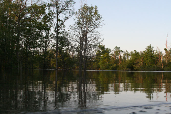
Pictured above: A look at the Escamia River at Fairgrounds Park. The park’s boardwalk and boat launch are under the flooded river. NorthEscambia.com file photo, click to enlarge.
Comments
6 Responses to “Flooding: When Does The Escambia River Flood Century, McDavid And Molino?”
WoW Trish, What a great letter; in fact, It is you that I think should run for County Commissioner or even the State Legislature! YOU have some great ideas about public safety and how individuals can be encouraged to establish and implement their own emergency preparedness plan.
Also, I like the link provided by “Shaun” to http://floridadisaster.org/family as a resource. Trish, I think you sell yourself short; I know you say you don’t want to hear about the poor, but yet you imply that you have once been there yourself. It sounds like those days were painful for you, and yet you struggled your way up to a comfortable position in life by taking care of the details and with good planning and hard work. You are obviously using your experiences to help others less capable than you to work their way up as well, by sharing your ideas on North Escambia. Good Job, Trish! (And Shaun).
I agree that everyone should have their own disaster plan.. Its easy to do here http://floridadisaster.org/family I encourage every family to create themselves one personally.
I’ve heard that when the Escambia River flooded in 1990 and reached the 24″ height ,as stated in the article, it actually went over Quintette Hwy near the river. And this was from rain north in the Century area. I quess a lot depends on how fast the rain happens and how fast it could have a domino effect.
Mr. Moran,
You seem to disagree with everything that is done. If you are so sure that all elected officials are wrong then why don’t you run for county commissioner or move into Century city limits and run for the council?
We elect officials to work out the details. The county does have shelters, one of which is down the road from my house. If John Q. public does not know about information it is because they don’t bother to find out for themselves. Individuals should have their own plans for disasters. Before hurricane season I start thinking of what we as a family need to do. And I don’t want to hear about the poor. When I was younger and had small children I was not even close to middle class income. But still, every storm season I had a plan. If you live in a low lying area you would have to be dumb as dirt not know that it could flood. If you live next to the river, expect it to flood. If you live north of Cantonment there is no excuse why you would not know that there are areas on hwy 29 that floods and the road has to be closed until the water goes down. Common sence and personal responsibility. Officials can post all of the information you want but most people don’t bother to pay attention.
Other than that we vote for who we think will work out the details.
If you don’t like what our elected officials are doing please run for office.
It should probably be illegal, to log, clear, or disturb in any way, land within a half mile or a mile of a major river like Escambia/Conecuh River. And it should be vigorously enforced, probably via air surveillance. Forests should grow undisturbed to absorb and delay runoff from long and heavy rains. That should also apply to most creeks that feed into them to a lesser degree. This would reduce flooding and conserve wildlife and help to keep water free of chemical pollution from herbicides, insecticides, soluble fertilizers, etc.
I’m ignorant of current laws along these lines. Not sure if such a law is implemented in Alabama but it seems to be more so in Florida with “watershed management areas”. I think Alabama needs to get their act together on this. I’ve seen clear-cut, logged land almost right down to the water’s edge in Alabama. Such land should be removed from Timber/paper industry ownership for the greater good or, as with drug dealers, the land should be confiscated when violations of the above suggested laws are discovered.
Great Flood Stage Legend William!
This is the kind of information that needs to be included in the Flooding Section of the Emergency and Disaster Response Plan for North Escambia.
Someone suggested that the people write a Disaster Plan, and I think NorthEscambia.com just started it! Like Wikipedia, the blog encyclopedia I think maybe the people of NorthEscamia have enough sense to see the need for and know the kinds of information needed for a Disaster Plan. Someone once told me that a camel was a pony designed by a committee. Well, be that as it may, the camel works very well in the local it lives in.
I think it is important to note that Century is not the only community that needs a Disaster Plan. So does Walnut Hill, Bratt, Byrneville, McDavid, Molino, Cantonment, and the West side of the county too.
The North Escambia Disaster Plan would be an “unofficial” document, but it would certainly be helpful to a lot of folks. I think it would be reasonable to define a shelter area for each of the communities mentioned in the NorthEscambia flood stage article; like Century, Mystic Springs, Bluff Springs, Molino, etc. even if those shelters are few and centrally located like in Molino and Century.
Include a section on Flooding, one on Hurricanes, one on Tornados, one on Rail Road or Trucking Spills, and even a section on Terrorist Attack (we are very close to several military bases) would be good. It would also be good to have a map showing the location of the designated shelters and a description of the kinds of support available at the shelter, like special medical needs. Telephone numbers for transportation assistance would be good too.
Does anyone else have any ideas or suggestions?