

Latest Headlines
- Cantonment Man Charged With Aggravated Assault With A Deadly Weapon
- Free Mississippi State, Florida, LSU Women’s Soccer Games Saturday At Ashton Brosnaham
- Flooding Collapses Road, Closes Bridges, Causes Wreck
- Walking Path, Parking Expanded At Cantonment’s Recently Opened Paper Park
- Pilot Program Seeks To Put Trade Certified Century Prison Releasees To Work
- Former Corrections Officer Trainee Charged With Smuggling Contraband Into Fountain Prison
- Crude Oil Prices Fall To 4-Year Lows
- These Are This Week’s Road Construction Trouble Spots
- Praytor’s Homer In Debut Pushes Wahoos To Series Sweep
- Tate Softball’s Strike Out Cancer Games Approaches Quarter Million Dollars For Fight Against Cancer

North Escambia Area Now Appears On Google Maps Street View
December 10, 2008
Google has expanded their Street View service to provide 360 degree ground level photos on their Google Maps service.
What exactly is Street View? It is exactly that, a street level panorama view from a large number of public roads in North Escambia, along with all of the surrounding communities. With Google Maps, you can view a map of your house and a satellite view of it from space. Now, with Street View, you can view an actual photo of your house and turn around 360 degrees in your front yard.
The inclusion of North Escambia was part of a major addition of cities, towns and rural areas to Street View on Tuesday.
“With just 22 days left in the year, I can’t help but think back to where Street View was at the beginning of 2008. At that time, we had imagery for 23 cities in the United States, and we had just released embeddable panoramas. Although Street View was still in its infancy, we were excited about the user feedback we had gotten and the creative uses we were seeing,” Google Product Manager Stephen Chau wrote in the official Google Blog.
“So we started 2008 with a clear, simple goal: bring Street View to more people in more places. Every time we add imagery for a new city or town, we’re not just benefiting its citizens, who now can preview their driving route or check for parking meters outside their dentist’s office, but anyone traveling to that place or teaching about it or simply curious to see more of the world,” Chau wrote.
It appears that the Google Street View photos in an around North Escambia were taken in the last half of February or the first half of March 2008. We based that conclusion on a few clues:
- There were no leaves on the trees.
- There were no Christmas decorations is Atmore, Flomaton or Century.
- The movie being show at the theater in Atmore was not released until February 14, 2008.
- The gas pumps at the Tom Thumb in Molino are missing; they were replaced in the last half of February 2008.
We did find a several roads in North Escambia that were not photographed by Google, but some of the most remote locations in the area were included.
To try Google Street View for yourself, visit maps.google.com
If you find something interesting in Google Street View around the area, let us know about it in the comments section below. You can click the “link” button in street view and paste a link to your interesting find below.
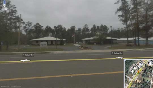
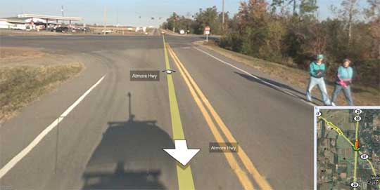
Pictured above: The Google Street View of the library and town hall in Century. Pictured below: In this Google Street View photo looking toward the Highway 29 and Highway 97 intersection in Molino, you can see a shadow of the vehicle used to take the photos. Note the pole with camera on top. You can also see to people out for a morning walk that were captured by the Street View cameras.
Comments
6 Responses to “North Escambia Area Now Appears On Google Maps Street View”
The pictures on South Pine Barren Rd were taken around christmas time. Our christmas decorations are still out. Also the addresses for South Pine Barren Rd are wrong,they seem to be backwards.
Jon
Cheapest advertising I could find. What could be better than Google except maybe Northescambia.com
Hey Kevin Mininger! What you got to pay Google to get this kind of advertising??? Nice lettering on that trailer!
http://maps.google.com/?ie=UTF8&ll=30.88685,-87.497306&spn=0,359.974015&t=h&z=16&layer=c&cbll=30.887202,-87.493561&panoid=Bm_yUG7zCdW8IMChV257DA&cbp=12,175.6416688814433,,0,26.849710982658965
The photos on Gobbler Rd. were taken between Thanksgiving and New Year’s, as our Christmas decorations were out in the photo.
The photos on 99 N @ Oak Grove Baptist Church were before the first primary in January, the church remodeling had not started yet.
Anyone else key in a Hwy 4 address and have the map show it as Bratt Road?
THIS IS SO COOL! I live on Rockaway and the only section that is missing is the area where I live (haha).